Latitude vs Longitude: The Difference and How to Read Them
Published
Latitude is the angle north or south of the equator, and longitude is the angle east or west of the prime meridian through Greenwich, London. Latitude runs from 0° at the equator to 90° at the poles (written N or S, or +90° to -90°), while longitude runs from 0° at Greenwich to 180° east or west (written E or W, or +180° to -180°).
The quickest way to tell them apart is the ladder rule: lat is flat. Lines of latitude lie flat like the horizontal rungs of a ladder, wrapping east to west around the globe parallel to the equator. Lines of longitude are the long vertical curves that run all the way from the North Pole to the South Pole, like the segments of a peeled orange.
0° to 90°N or S
latitude range
Measured north or south from the equator
0° to 180°E or W
longitude range
Measured east or west from Greenwich
111km
ground length of 1° of latitude
110.6 km at the equator to 111.7 km at the poles
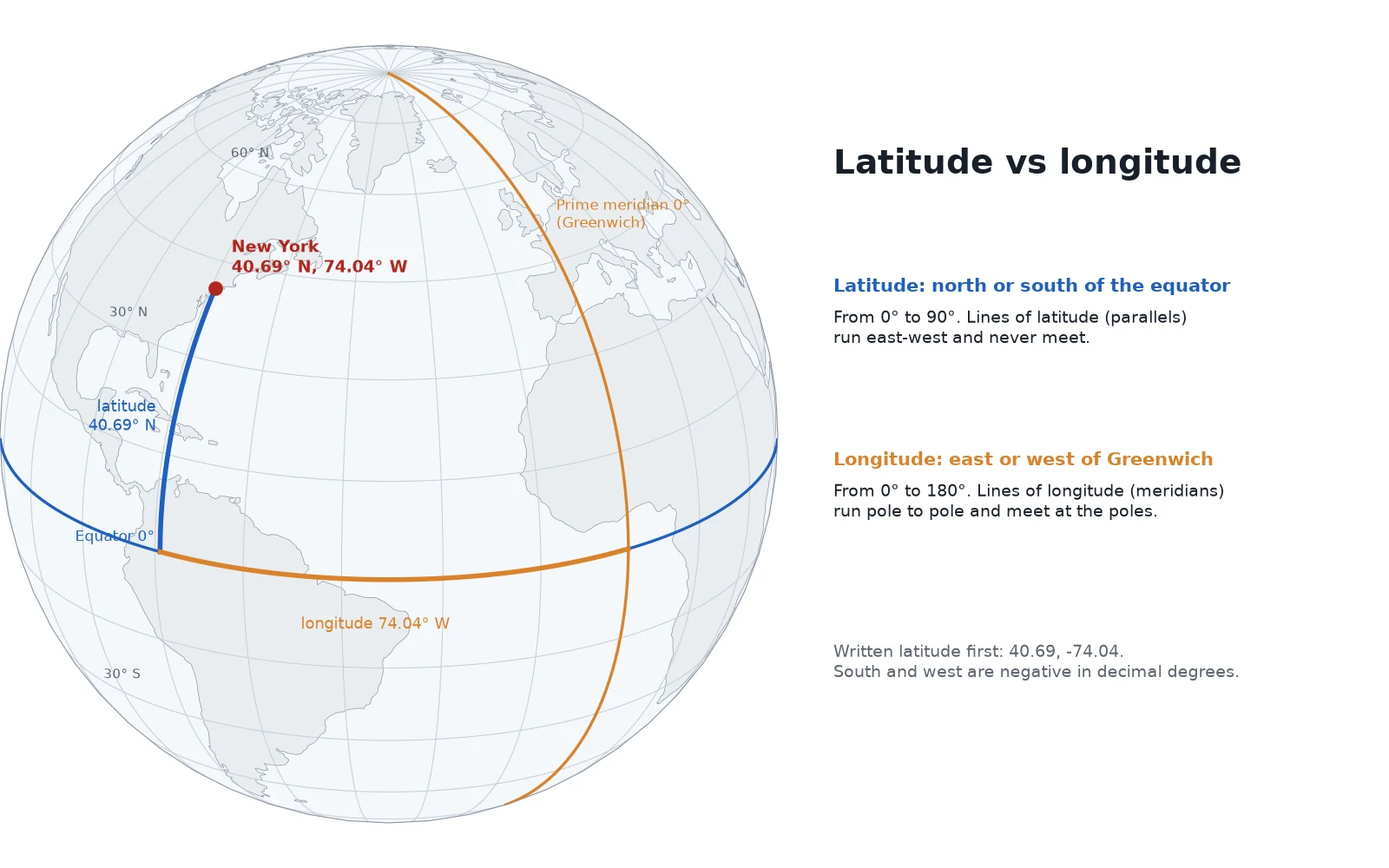
Latitude vs longitude: side-by-side comparison
Every point on Earth is fixed by where its parallel of latitude crosses its meridian of longitude. The two numbers look similar on screen, so watch the range and the direction letter. Any coordinate above 90° (or below -90°) can only be a longitude.
| Feature | Latitude | Longitude |
|---|---|---|
| What it measures | Angle north or south of the equator | Angle east or west of the prime meridian |
| Direction of the lines | Horizontal (run east to west) | Vertical (run north to south, pole to pole) |
| Name of the lines | Parallels | Meridians |
| Reference line (0°) | The equator | The prime meridian (Greenwich, London) |
| Range in degrees | 0° to 90° N or S (-90° to +90°) | 0° to 180° E or W (-180° to +180°) |
| Positive and negative | North is +, South is - | East is +, West is - |
| Do the lines meet? | Never; they stay parallel and shrink toward the poles | Yes; every meridian meets at the North and South Poles |
| Length of 1 degree | About 111 km everywhere (110.6 to 111.7 km) | 111.3 km at the equator, shrinking to 0 km at the poles |
| Cartesian axis in GIS | Y axis (northing) | X axis (easting) |
What is latitude?
Latitude is the angular distance of a place north or south of the Earth's equator, measured in degrees from the centre of the planet. The equator sits at 0° latitude and splits the globe into the Northern and Southern Hemispheres. Moving north, latitude climbs to 90°N (+90°) at the North Pole; moving south, it reaches 90°S (-90°) at the South Pole.
Lines of constant latitude are called parallels because they run parallel to the equator and to one another. Every parallel is a full circle that runs east to west around the Earth, and no two parallels ever touch. The equator is the longest parallel at about 40,075 km (24,901 miles) around. As you travel toward either pole, the horizontal rings draw smaller and smaller until the 90° parallel shrinks to a single point at the pole.
Five parallels have special names because they mark how the Earth's 23.4-degree axial tilt lines up with the Sun over the year:
- Arctic Circle (about 66.6°N): The southernmost latitude in the Northern Hemisphere that experiences at least one 24-hour day of midnight sun in summer and one 24-hour polar night in winter.
- Tropic of Cancer (about 23.4°N): The northernmost latitude where the Sun can stand directly overhead at noon, on the June solstice.
- Equator (0°): The line halfway between the poles where day and night stay near 12 hours all year.
- Tropic of Capricorn (about 23.4°S): The southernmost latitude where the Sun stands directly overhead at noon, on the December solstice.
- Antarctic Circle (about 66.6°S): The northernmost latitude in the Southern Hemisphere with a 24-hour summer day and a 24-hour winter night.
What is longitude?
Longitude is the angular distance of a place east or west of the prime meridian, measured in degrees from 0° to 180°. Unlike latitude, which has the equator as a natural middle line set by the Earth's rotation axis, longitude has no physical starting line on the globe. Any north-south line could serve as zero. For centuries, countries drew their own zero line: French charts measured longitude from Paris, British charts from Greenwich. In 1884, delegates at the International Meridian Conference in Washington agreed on a single global zero line: the prime meridian passing through the Royal Observatory in Greenwich, London.
From 0° at Greenwich, longitude counts eastward to 180°E (+180°) across Europe, Asia and Australia, and westward to 180°W (-180°) across the Atlantic and the Americas. The 180°E and 180°W meridians are the exact same line on the far side of the Pacific Ocean, opposite Greenwich, where they form the spine of the International Date Line.
Lines of constant longitude are called meridians. Every meridian is a half-circle of equal length, running about 20,004 km (12,430 miles) from the North Pole to the South Pole. Whereas parallels stay the same distance apart everywhere, meridians spread widest at the equator and pinch closer together as they approach the poles, until all 360 degrees of longitude meet at a single point at the North Pole and again at the South Pole.
Which comes first, latitude or longitude?
In everyday writing, navigation and web maps, latitude comes first and longitude comes second. The Statue of Liberty in New York is written 40.6892° N, 74.0445° W, or 40.6892, -74.0445 in decimal degrees. Google Maps and the ISO 6709 standard notation put latitude first.
Most GIS file formats and programming libraries reverse that order and store longitude first, then latitude, so that the coordinates match Cartesian (X, Y) math on a flat graph. Because longitude moves left and right (east and west), it is the X coordinate; because latitude moves up and down (north and south), it is the Y coordinate.
Whenever your imported points show up in Antarctica, in the Indian Ocean off Somalia, or mirrored across a 45-degree diagonal line, check whether the file swapped X (longitude) and Y (latitude).
How to read and convert coordinate formats (DD, DMS, DDM)
Every latitude and longitude pair can be written in three standard notations. They all point to the exact same spot on the globe and differ only in how they split up fractions of a degree:
- Decimal Degrees (DD): Writes the fraction of a degree as a normal decimal number, such as
48.8584, 2.2945. North and east are positive; south and west use a minus sign (-). This is the cleanest format for spreadsheets, databases and GIS software. - Degrees, Minutes, Seconds (DMS): Splits each degree into 60 arc-minutes (
') and each minute into 60 arc-seconds ("), followed by the hemisphere letter (N,S,E,W), such as48°51'30.2"N 2°17'40.2"E. Printed topographic maps, aviation charts and land deeds often use DMS. - Degrees and Decimal Minutes (DDM): Splits the degree into 60 minutes and writes the remainder as a decimal of a minute, such as
48°51.504'N 2°17.670'E. Marine navigation radios, coast guards and geocaching use DDM.
The table below shows the same five landmarks written across all three formats:
| Place | Decimal degrees (DD) | Degrees, minutes, seconds (DMS) | Degrees and decimal minutes (DDM) |
|---|---|---|---|
| Eiffel Tower, Paris | 48.8584, 2.2945 | 48°51'30.2"N 2°17'40.2"E | 48°51.504'N 2°17.670'E |
| Statue of Liberty, New York | 40.6892, -74.0445 | 40°41'21.1"N 74°02'40.2"W | 40°41.352'N 74°02.670'W |
| Christ the Redeemer, Rio de Janeiro | -22.9519, -43.2105 | 22°57'06.8"S 43°12'37.8"W | 22°57.114'S 43°12.630'W |
| Tokyo Tower | 35.6586, 139.7454 | 35°39'31.0"N 139°44'43.4"E | 35°39.516'N 139°44.724'E |
| Sydney Opera House | -33.8568, 151.2153 | 33°51'24.5"S 151°12'55.1"E | 33°51.408'S 151°12.918'E |
How to convert DMS to decimal degrees
Because a degree has 60 minutes and 3,600 seconds (60 × 60), you convert DMS to decimal degrees with one formula:
Decimal Degrees = Degrees + (Minutes / 60) + (Seconds / 3600)
If the coordinate is South (S) or West (W), put a minus sign in front of the finished result. Take the latitude of the Eiffel Tower, 48°51'30.2"N:
- Keep the whole degrees:
48. - Divide the minutes by 60:
51 / 60 = 0.85. - Divide the seconds by 3,600:
30.2 / 3600 = 0.008389. - Add the three parts together:
48 + 0.85 + 0.008389 = 48.8584°.
To convert without doing the arithmetic by hand, paste any DMS, DDM or decimal string into our free coordinate converter, which translates single points or bulk lists between formats and projected grids.
How many decimal places do you need?
Adding extra digits after the decimal point makes a coordinate look precise, but beyond five or six places you are measuring centimetres and millimetres that no consumer GPS can see. At the equator, each extra decimal place cuts the ground uncertainty by a factor of 10:
| Decimal places | Example (latitude) | Ground precision at the equator | Typical use |
|---|---|---|---|
| 0 | 49° | About 111 km | Country or large region |
| 1 | 48.9° | About 11 km | Large city or metropolitan area |
| 2 | 48.86° | About 1.1 km | Town, district or neighborhood |
| 3 | 48.858° | About 111 m | Street, large field or campus |
| 4 | 48.8584° | About 11 m | Individual building or parcel |
| 5 | 48.85837° | About 1.1 m | Trees, entrances, phone GPS limit |
| 6 | 48.858370° | About 11 cm | Survey monuments, RTK GNSS |
A smartphone GPS is typically accurate to a few metres under open sky, so 5 decimal places (about 1.1 m) captures everything the sensor actually knows. Storing 12 decimal places from a software export does not make the point more accurate.
How many kilometres is one degree of latitude and longitude?
Because latitude and longitude are angles rather than flat grid distances, the ground length of 1 degree depends on which direction you measure and how close you are to the poles.
One degree of latitude is always close to 111 km (69 miles) anywhere on Earth. If the Earth were a perfect sphere, every degree of latitude would be identical. Because the spinning planet bulges slightly at the equator and is flattened at the poles, the curvature is slightly tighter at the equator and flatter near the poles. Computed on the standard WGS 84 ellipsoid, 1° of latitude measures 110.574 km at the equator, 111.132 km at 45° latitude, and 111.694 km at the poles. Dividing one degree of latitude into 60 minutes gives about 1.85 km per minute of latitude, which is where the international nautical mile (defined as exactly 1,852 m) comes from. One arc-second of latitude is about 31 m (101 feet) on the ground.
One degree of longitude shrinks from 111.3 km at the equator to 0 km at the poles. At the equator, a degree of longitude is 111.319 km wide, almost the same as a degree of latitude. As you travel north or south, the meridians converge toward the poles roughly with the cosine of the latitude:
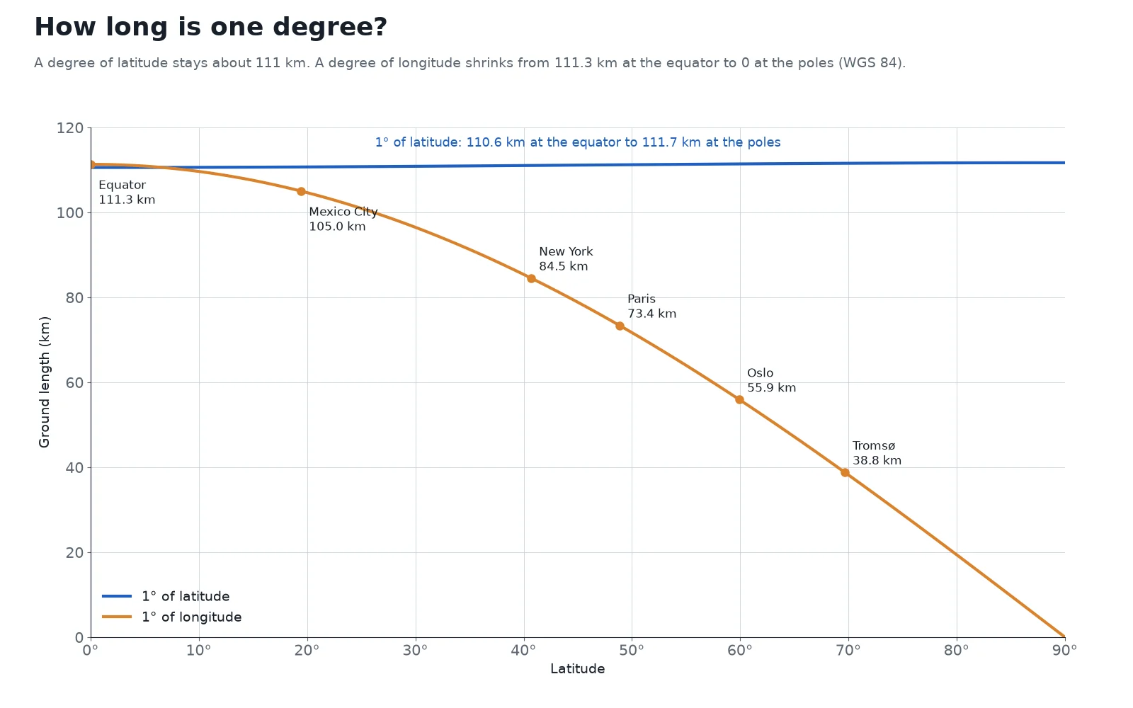
The table below lists the ground length of 1° of latitude and 1° of longitude on the WGS 84 ellipsoid from the equator to the pole, along with five cities:
| Latitude / City | Length of 1° of latitude | Length of 1° of longitude |
|---|---|---|
| 0° (Equator) | 110.574 km | 111.319 km |
| 15° | 110.649 km | 107.550 km |
| 19.43°N (Mexico City) | 110.697 km | 105.0 km |
| 30° | 110.852 km | 96.486 km |
| 40.69°N (New York) | 111.048 km | 84.5 km |
| 45° | 111.132 km | 78.846 km |
| 48.86°N (Paris) | 111.207 km | 73.4 km |
| 59.91°N (Oslo) | 111.411 km | 55.9 km |
| 60° | 111.412 km | 55.799 km |
| 69.65°N (Tromsø) | 111.558 km | 38.8 km |
| 75° | 111.618 km | 28.902 km |
| 90° (Poles) | 111.694 km | 0.000 km |
Because 1° of longitude is 105.0 km wide in Mexico City, 73.4 km wide in Paris and only 38.8 km wide in Tromsø, you cannot measure distances, buffers or parcel areas directly in degrees. Subtracting two latitude-longitude pairs and applying the Pythagorean theorem treats a degree of longitude as if it were the same width as a degree of latitude, which stretches east-west distances everywhere away from the equator.
To find the real ground distance between two latitude-longitude points, use ellipsoidal math in our distance calculator. When you work in GIS, reproject your layer into a flat metre grid such as your local UTM zone or a national coordinate system; our guides on what a CRS is and map projections show how projections turn degrees into metres.
Notice also that a latitude and longitude pair only points to a single spot on the ground when you name the datum (the ellipsoid model of the Earth) it was measured on. GPS receivers and web maps use the global WGS 84 datum, known in GIS by the code EPSG:4326. The exact same latitude and longitude numbers referenced to an older datum such as NAD27 in North America or ED50 in Europe can point to a spot many metres away on the ground.
How to find your latitude and longitude (and load them in QGIS)
To look up the coordinates of your current location or any address on Earth, open our free GPS coordinates finder. Click anywhere on the map or use your browser's location button to read the point simultaneously in decimal degrees, DMS, UTM metres and MGRS.
On Google Maps on a computer, right-click any spot on the map: the decimal latitude and longitude appear at the very top of the pop-up menu (such as 48.85837, 2.29448), and clicking the numbers copies them to your clipboard. On the Google Maps mobile app, press and hold your finger on an unlabelled spot on the map to drop a red pin; the latitude and longitude appear in the search bar at the top of the screen.
How to map latitude and longitude from a CSV in QGIS
When you have a spreadsheet of points with latitude and longitude columns and want to map them in QGIS, load the file as a delimited text layer so you can tell QGIS which column is X and which is Y.
 , load the file as a delimited text layer so you can tell QGIS which column is X and which is Y.
Open Add Delimited Text Layer
In QGIS, open Layer > Add Layer > Add Delimited Text Layer from the top menu, and click the
...browse button to select your.csvfile.Assign longitude to X and latitude to Y
Open the Geometry Definition section and select Point coordinates. Set the X field dropdown to your Longitude column and the Y field dropdown to your Latitude column. Reversing these two dropdowns is what sends a layer to the wrong continent.
Set the Geometry CRS to EPSG:4326 and add the layer
Set Geometry CRS to
EPSG:4326 - WGS 84(the standard CRS for GPS decimal degrees), check the sample table at the bottom to make sure the numbers parse cleanly, and click Add.
Once the layer is on the map, you can also read live coordinates anywhere on the canvas: when the project CRS in the bottom-right corner is set to EPSG:4326, the Coordinate box in the QGIS status bar at the bottom of the window displays the cursor's position in degrees.
If your CSV has messy DMS strings, mixed columns or needs to be reprojected into metres right away, AI Agent, the QGIS plugin we build, can load the file, match the latitude and longitude columns, set the CRS and style the points on the map from a single sentence in the side panel.
Read nextUTM Zones Explained: Map of All 60, and How to Find Yours
Questions people ask
In everyday writing, GPS displays and Google Maps, latitude is always written first and longitude second, such as 40.6892, -74.0445 for the Statue of Liberty. In most GIS file formats and code libraries, including GeoJSON (RFC 7946), Shapefiles and PostGIS, longitude is stored first and latitude second so the pair matches Cartesian (X, Y) coordinate order.
Latitude measures how far north or south a point sits from the equator, ranging from 0° at the equator to 90°N or 90°S at the poles. Longitude measures how far east or west a point sits from the prime meridian in Greenwich, London, ranging from 0° to 180°E or 180°W.
Lines of latitude (parallels) are horizontal rings that run east to west around the globe parallel to the equator, even though the angle of latitude measures position north and south. Lines of longitude (meridians) are vertical half-circles that run north to south from pole to pole, while measuring position east and west.
You can click any location on our free GPS coordinates finder to read its latitude and longitude in decimal degrees and DMS, or use your device's GPS to get your current position. On Google Maps on a computer, right-click any spot on the map and click the decimal coordinates at the top of the menu to copy them.
One degree of latitude is about 111 km (69 miles) everywhere on Earth. Because the Earth is slightly flattened at the poles, the exact ground length on the WGS 84 ellipsoid grows slightly from 110.574 km at the equator to 111.132 km at 45° and 111.694 km at the poles. One degree of longitude, by contrast, is 111.319 km at the equator and shrinks to 0 km at the poles.
Divide the minutes by 60, divide the seconds by 3,600, and add both fractions to the whole degrees: DD = Degrees + (Minutes / 60) + (Seconds / 3600). Make the final number negative if the hemisphere is South (S) or West (W), or paste the coordinate into our coordinate converter to convert it automatically.
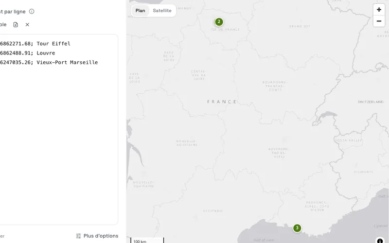
Do it in QGIS by asking for it
AI Agent carries out the task you describe, in your own QGIS project. Free, no card.