UTM Zones Explained: Map of All 60, and How to Find Yours
Published
A Universal Transverse Mercator (UTM) zone is one of 60 vertical strips that divide the Earth between 80°S and 84°N to project the round planet onto a flat grid measured in metres. Each zone is 6 degrees of longitude wide, numbered 1 to 60 eastward starting at 180°W, and keeps scale distortion below 1 part in 1,000 within its borders.
Think of the system as peeling an orange into 60 narrow slices and pressing each slice flat on its own table. A single world map projection stretches the poles or warps areas, so the USGS and national mapping agencies use these 60 narrow projections instead. Inside a single slice, the curve of the Earth is small enough that you can measure distances and areas directly in metres with flat geometry.
60zones
6° of longitude each
Numbered 1 to 60 from 180°W eastward
500,000m
false easting on the centre line
Keeps every easting positive across the zone
< 0.1%distortion
scale error inside a zone
0.9996 at the centre to 1.00097 at the equator edge
What is the UTM coordinate system?
The Universal Transverse Mercator system is a set of 60 separate map projections that cover the globe from 80°S to 84°N. Instead of using angles of latitude and longitude, UTM gives every point an easting and a northing in metres inside its local zone.
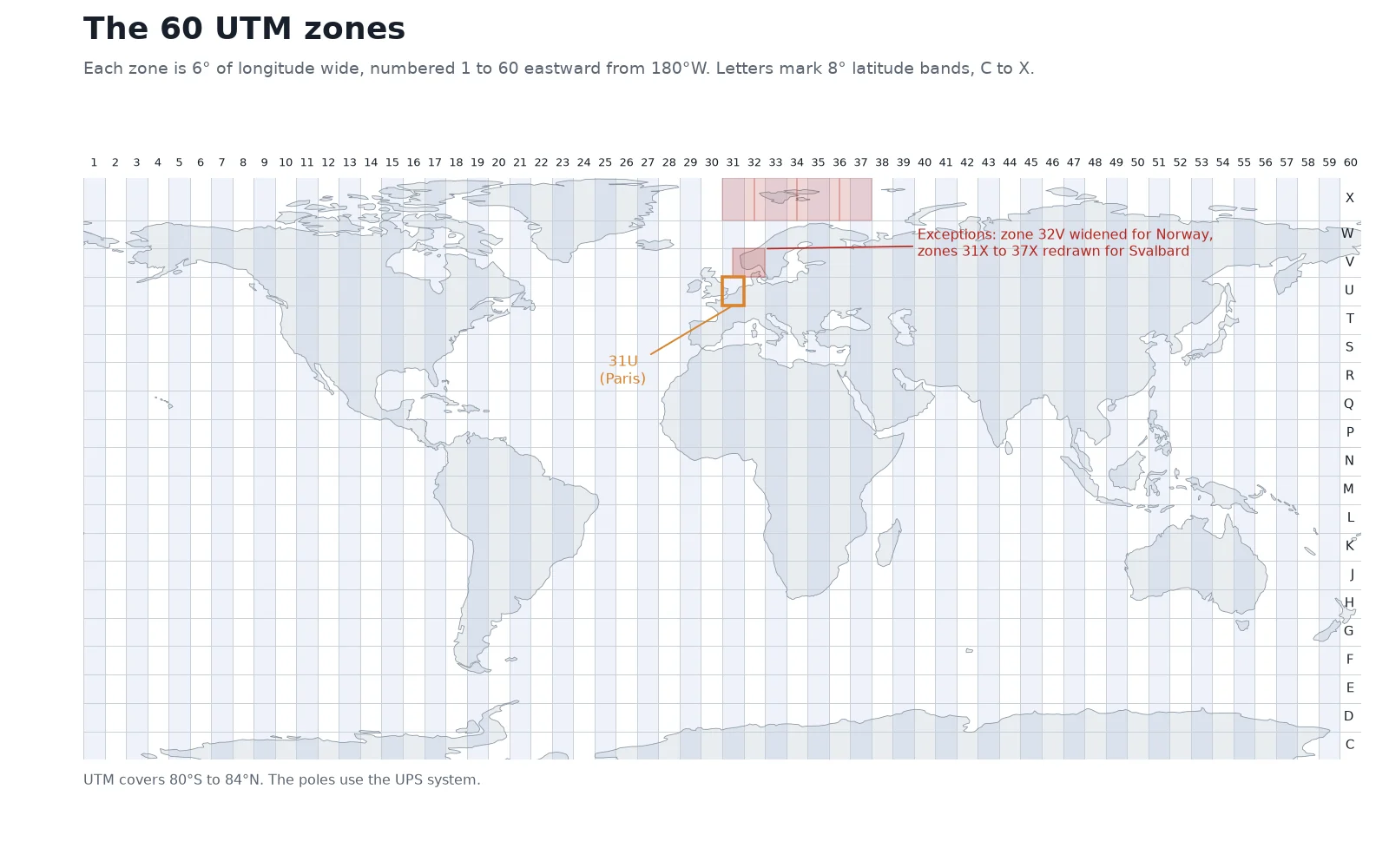
Zone 1 runs from 180°W to 174°W in the Pacific Ocean. The numbering moves east by 6 degrees per step: zone 30 covers 6°W to 0° (most of Spain and western Britain), zone 31 covers 0° to 6°E (Paris and eastern Spain), and zone 60 closes the ring from 174°E to 180°. The polar caps south of 80°S and north of 84°N are left out because the narrow slices meet at a point at the poles; those regions use the Universal Polar Stereographic (UPS) system instead.
Each 6-degree strip is also cut horizontally into 20 latitude bands, lettered C to X from south to north. The letters I and O are skipped so nobody mistakes them for the digits 1 and 0. Nineteen of the bands are 8 degrees of latitude tall, and the northernmost band, X, is extended to 12 degrees so it reaches from 72°N to 84°N. Bands C through M sit in the southern hemisphere, and bands N through X sit in the northern hemisphere.
Two regions break the neat 6-degree grid so that coastal land is not split across two zones:
- Southwest Norway (cell 32V): Between 56°N and 64°N, zone 32V is widened westward to run from 3°E to 12°E, covering the entire southern Norwegian coast in one zone. Its neighbor, zone 31V, shrinks to 3 degrees wide over the North Sea.
- Svalbard (band X): Between 72°N and 84°N, the converging meridians make the standard zones very narrow. Zones 32X, 34X and 36X are dropped completely, and zones 31X (9 degrees wide), 33X (12 degrees), 35X (12 degrees) and 37X (9 degrees) are widened to cover the archipelago.
How to read a UTM coordinate: easting and northing
A UTM coordinate has three parts: the zone (with its hemisphere or latitude band), the easting in metres, and the northing in metres. For the Eiffel Tower in Paris (48.8584°N, 2.2945°E), the WGS 84 UTM coordinate is 31U 448252 E 5411955 N.
31Uis the zone and band. The point sits in longitude zone 31 (0° to 6°E) and latitude band U (48°N to 56°N), which puts it in the northern hemisphere.448252 Eis the easting. It measures the position east or west of the zone's centre line, in metres. Because 448,252 m is less than 500,000 m, the Eiffel Tower stands 51,748 m (about 51.7 km) west of the 3°E central meridian.5411955 Nis the northing. In the northern hemisphere, it is the distance in metres along the grid from the equator. The Eiffel Tower is about 5,412 km north of the equator.
False easting, false northing and the 0.9996 scale factor
Every UTM zone uses its own Transverse Mercator projection wrapped around the zone's central meridian. For zone 31, running from 0° to 6°E, that centre line is the 3°E meridian.
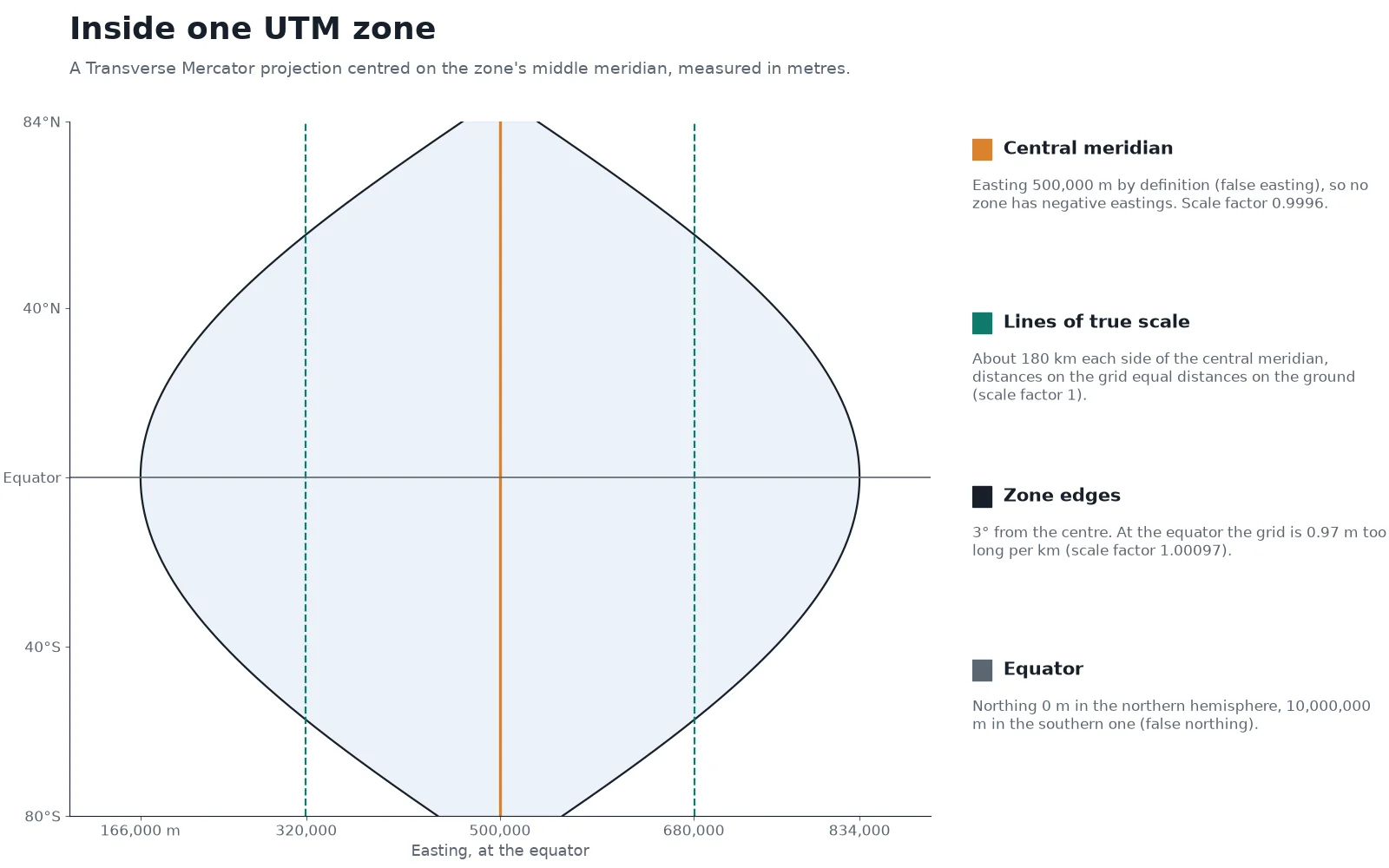
If the central meridian were given an x-coordinate of 0 m, the western half of every zone would have negative eastings. To avoid minus signs, UTM assigns the central meridian a false easting of 500,000 m. Anything west of the centre line has an easting under 500,000 m, and anything east of it has an easting over 500,000 m. At the equator, where a 6-degree zone is widest, eastings run from about 166,000 m on the western edge to 834,000 m on the eastern edge. Towards the poles the meridians draw closer together, so the range of eastings narrows, while the centre stays pinned at 500,000 m.
Northing uses a similar trick below the equator. In the northern hemisphere, northing starts at 0 m at the equator and counts upward toward 84°N. In the southern hemisphere, counting southward from zero would produce negative numbers, so UTM adds a false northing of 10,000,000 m at the equator. A point 1,000 km south of the equator has a northing of about 9,000,000 m.
To keep distortion low across the whole 6-degree width, the projection cylinder cuts slightly inside the ellipsoid instead of touching it at a single line. The scale factor on the central meridian is 0.9996, which means a 1,000 m ground distance across the centre line measures 999.60 m on the grid (40 cm shorter per kilometre). Moving outward from the centre, the scale factor climbs back to 1.0000 along two lines of true scale about 180 km to the east and west of the central meridian (around eastings 320,000 m and 680,000 m). At the outer edge of the zone on the equator, 3 degrees from the centre, the scale factor reaches 1.00097, so the grid is 0.97 m too long per kilometre. Across the entire zone, scale distortion remains below 1 part in 1,000.
You may also meet UTM coordinates written with extra letters in the middle, such as 31U DQ 48252 11955. That is the Military Grid Reference System (MGRS), which replaces the leading digits of the easting and northing with a two-letter code for each 100 km square. You can translate between MGRS strings, UTM metres and decimal degrees in our MGRS converter.
How do you find your UTM zone?
You can click any place on our UTM zone map to read its zone number, latitude band and EPSG code directly, or paste coordinates into the coordinate converter. If you have the longitude in decimal degrees, you can also calculate the zone number in one line.
The formula takes the longitude (with west longitudes written as negative numbers, from -180° to +180°), shifts it so the count starts at 180°W, and divides by the 6-degree zone width:
Zone = floor((longitude + 180) / 6) + 1
Here floor means rounding down to the nearest whole number. Take Madrid, at longitude -3.7038°:
- Add 180 to the longitude:
-3.7038 + 180 = 176.2962. - Divide by 6:
176.2962 / 6 = 29.3827. - Round down to the whole integer (
29) and add 1: Zone 30.
This formula works everywhere between 80°S and 84°N except inside the two rectangular grid exceptions over southwest Norway (56°N to 64°N, 3°E to 12°E, which forces zone 32) and Svalbard (72°N to 84°N, 0° to 42°E).
UTM zones and coordinates for major cities
The table below lists the WGS 84 UTM coordinates (EPSG:326xx north, EPSG:327xx south) for nine cities across Europe, the Americas and Asia, computed with proj4.
| City | Latitude, Longitude | UTM Zone | Easting (m) | Northing (m) | WGS 84 EPSG |
|---|---|---|---|---|---|
| Madrid | 40.4168, -3.7038 | 30T | 440,290 | 4,474,257 | EPSG:32630 |
| Mexico City | 19.4326, -99.1332 | 14Q | 486,017 | 2,148,700 | EPSG:32614 |
| São Paulo | -23.5505, -46.6333 | 23K | 333,288 | 7,394,588 | EPSG:32723 |
| Paris (Eiffel Tower) | 48.8584, 2.2945 | 31U | 448,252 | 5,411,955 | EPSG:32631 |
| Berlin | 52.5200, 13.4050 | 33U | 391,779 | 5,820,072 | EPSG:32633 |
| Rome | 41.9028, 12.4964 | 33T | 292,335 | 4,642,016 | EPSG:32633 |
| Jakarta | -6.2088, 106.8456 | 48M | 704,207 | 9,313,358 | EPSG:32748 |
| Tokyo | 35.6895, 139.6917 | 54S | 381,622 | 3,950,299 | EPSG:32654 |
| New York (Statue of Liberty) | 40.6892, -74.0445 | 18T | 580,736 | 4,504,695 | EPSG:32618 |
Notice how Jakarta (-6.2088°) and São Paulo (-23.5505°) both have northings above 7,000,000 m. Because they lie south of the equator, their northings are 10,000,000 m minus their distance from the equator.
UTM zones by country
Most medium and large countries span several 6-degree strips. When a project sits inside one region or province, pick the local zone; when a dataset covers a whole country across three or more zones, check whether the national mapping agency defines a single country-wide projection instead.
| Country | UTM zones covered | Notes |
|---|---|---|
| Spain | 29 to 31 (mainland), 27 and 28 (Canary Islands) | Zone 30 covers Madrid and the central plateau |
| Portugal | 29 (mainland) | Entire continental coast fits inside zone 29 |
| France | 30 to 32 (mainland) | Paris is in 31; national mapping often uses Lambert-93 |
| Germany | 32 and 33 (plus a sliver of the far west in 31) | Most federal states standardise on zone 32 or 33 |
| Italy | 32 to 34 | Northwest in 32, Rome and peninsular spine in 33, Apulia tip in 34 |
| Mexico | 11 to 16 | Tijuana in 11, Mexico City in 14, Cancún in 16 |
| Brazil | 18 to 25 | Eight zones from Acre in the west to the Atlantic coast; São Paulo is in 23 |
| United States (contiguous) | 10 to 19 | Seattle in 10, Los Angeles in 11, New York in 18, Boston in 19 |
| Indonesia | 46 to 54 | Nine zones across the archipelago; Jakarta is in 48 |
| Japan | 52 to 54 (main islands), 51 to 56 (outlying islands) | Tokyo sits in zone 54 |
UTM vs latitude and longitude
Both systems pinpoint the same places on Earth, but they solve different problems. Latitude and longitude are angles measured from the Earth's centre, whereas UTM coordinates are flat Cartesian distances in metres inside one zone.
| Feature | Latitude and longitude | UTM (Universal Transverse Mercator) |
|---|---|---|
| Units | Degrees (decimal degrees or degrees, minutes, seconds) | Metres (easting and northing) |
| Coverage | Seamless across the entire planet | Split into 60 separate 6° zones between 80°S and 84°N |
| Distance and area | Needs spherical or ellipsoidal math; 1° of longitude shrinks toward the poles | Direct flat-grid math (Pythagoras) within a single zone |
| Scale distortion | None on the 3D globe; severe away from the equator when plotted flat | Under 0.1% (1 part in 1,000) anywhere inside the zone |
| Best used for | GPS receivers, global databases, GeoJSON, web APIs | Land surveying, engineering, hiking maps, local GIS buffers and area measurements |
Use latitude and longitude when you store or exchange data that crosses countries or continents. Switch to UTM (or a national projected grid) before you run buffers, measure parcel areas or calculate distances in GIS.
The catch with UTM is the boundary between zones. Each zone has its own central meridian tilted gently toward the poles relative to its neighbors. A point at the eastern edge of zone 30 and a point a few metres away at the western edge of zone 31 have completely different easting numbers (at 40°N, about 756,000 m in zone 30 and about 244,000 m in zone 31), and their grid north arrows meet at a slight angle. You cannot subtract coordinates from zone 30 and zone 31 to find the distance between two points. When your study area crosses a 6-degree meridian, reproject both layers into the single UTM zone that holds the majority of your data.
EPSG codes for UTM zones (and the datum trap)
In GIS software, every UTM zone has an EPSG code that pairs the zone number and hemisphere with a specific datum. Our guide on what a CRS is explains how the datum and projection fit together, and you can search any code in the CRS lookup tool.
For the global WGS 84 datum, the codes follow a clean pattern where NN is the two-digit zone number (from 01 to 60):
- WGS 84 Northern Hemisphere:
EPSG:326NN. Zone 1N isEPSG:32601, zone 18N isEPSG:32618, and zone 31N isEPSG:32631. - WGS 84 Southern Hemisphere:
EPSG:327NN. Zone 18S isEPSG:32718, zone 23S isEPSG:32723, and zone 48S isEPSG:32748.
National and continental surveys rarely use WGS 84 directly. They tie their UTM grids to a regional datum anchored to the local tectonic plate. The projection math (6-degree zones, 500,000 m false easting, 0.9996 scale factor) is identical, but the underlying ellipsoid anchor differs slightly:
| Region | Datum | EPSG pattern | Example |
|---|---|---|---|
| Worldwide (GPS) | WGS 84 | EPSG:326NN (N) / EPSG:327NN (S) | EPSG:32631 (WGS 84 / UTM zone 31N) |
| Europe | ETRS89 | EPSG:258NN | EPSG:25831 (ETRS89 / UTM zone 31N) |
| North America | NAD83 | EPSG:269NN | EPSG:26918 (NAD83 / UTM zone 18N) |
| South America / Brazil | SIRGAS 2000 | EPSG:319xx | EPSG:31983 (SIRGAS 2000 / UTM zone 23S) |
For the exact same ground monument, a coordinate in EPSG:32631 (WGS 84) and EPSG:25831 (ETRS89) can differ by close to a metre, because ETRS89 is fixed to the European plate, which has drifted since 1989, while WGS 84 follows the whole Earth. NAD83 and WGS 84 differ by a metre or two in North America for the same reason. On a regional thematic map that shift is invisible, so people often treat them as interchangeable. On a cadastral survey, utility trench or drone orthomosaic, a one-to-two-metre offset shows up right away. Always check whether a shapefile or CAD drawing supplied in "UTM 31N" was surveyed in WGS 84 or the regional datum before setting its CRS.
How to use UTM zones in QGIS
When you load a layer in EPSG:4326 (latitude and longitude) into QGIS and want to measure lengths, build a metre buffer or prepare a georeferencing project in QGIS, switch either the project view or the layer itself to the local UTM zone.
 and want to measure lengths, build a metre buffer or prepare a
Find the right UTM EPSG code
Look up your study area on the UTM zone map to get the zone number and hemisphere, or pick the regional code (
EPSG:326xxfor WGS 84 north,EPSG:327xxfor WGS 84 south,EPSG:258xxfor ETRS89 in Europe,EPSG:269xxfor NAD83 in North America). If your data crosses a zone border, pick the zone that covers most of your features.Set the QGIS project CRS for display
Click the
EPSG:...button in the bottom-right corner of the QGIS status bar (or open Project > Properties > CRS). TypeUTM zone 31Nor32631into the filter box, select the coordinate system from the list, and click OK. QGIS now draws the map canvas in that UTM grid on the fly without altering your files on disk.Reproject a vector layer to save it in metres
To run distance or area tools that depend on the layer's own units, convert the file itself: open Vector > Data Management Tools > Reproject Layer (or search Reproject layer in the Processing Toolbox). Choose your input layer, set Target CRS to your UTM EPSG code, and click Run to create a new layer whose coordinates are stored in UTM metres.
Never use Set Layer CRS to convert a latitude/longitude file into UTM. Set Layer CRS only swaps the metadata label while keeping the tiny degree numbers (such as 2.29, 48.85), which drops your entire layer a few metres from the equator, about 500 km west of the zone's central meridian, in the Gulf of Guinea. Use Reproject Layer whenever the starting CRS is already right and you want the numbers recalculated into metres.
If you have half a dozen layers in mixed coordinate systems and do not want to look up the zone number by hand, AI Agent, the QGIS plugin we build, can inspect the project extent, pick the matching UTM zone and reproject the layers from a single prompt in the side panel.
Questions people ask
A UTM zone is one of 60 vertical strips, each 6 degrees of longitude wide, that divide the Earth between 80°S and 84°N in the Universal Transverse Mercator system. Each zone applies its own Transverse Mercator projection centred on the middle meridian of that strip, turning latitude and longitude into flat easting and northing coordinates in metres with less than 0.1% scale distortion.
There are 60 UTM longitude zones covering the globe, numbered 1 to 60 eastward starting at the 180° meridian in the Pacific Ocean. Because each zone is 6 degrees wide, the 60 zones add up to the full 360 degrees of longitude (60 × 6° = 360°). Each zone is further split by the equator into a northern and a southern hemisphere CRS, or into 20 latitude bands lettered C to X.
You can click your location on our interactive UTM zone map or calculate the zone number directly from your longitude in decimal degrees (with west negative) using floor((longitude + 180) / 6) + 1. For example, Madrid at longitude -3.70° gives floor(176.30 / 6) + 1 = 30, placing it in UTM zone 30N (EPSG:32630).
Latitude and longitude are angles in degrees on a curved ellipsoid that work seamlessly across the whole planet, but a degree of longitude changes width with latitude, so you cannot measure distances with flat geometry. UTM projects a 6-degree strip onto a flat grid in metres, letting you measure distances and areas directly within one zone at the cost of breaking continuity across zone boundaries.
Easting and northing are the x and y coordinates, measured in metres, inside a projected grid such as a UTM zone. The easting gives the position relative to the zone's central meridian (which is set to 500,000 m), and the northing gives the distance in metres north of the equator (or down from 10,000,000 m in the southern hemisphere).
A UTM projection is centred on the middle meridian of its 6-degree zone, so assigning that line 0 m would give the entire western half of the zone negative easting coordinates. Giving the central meridian a false easting of 500,000 m shifts every coordinate across the full width of the zone into positive numbers, ranging from about 166,000 m to 834,000 m at the equator.
Mainland Spain spans UTM zones 29, 30 and 31 (with the Canary Islands in zones 27 and 28, and Madrid in 30T). Mexico spans six zones from 11 in Baja California to 16 in the Yucatán Peninsula, with Mexico City in zone 14Q. Brazil spans eight zones from 18 in the western Amazon to 25 on the eastern coast, with São Paulo in zone 23K.
Do it in QGIS by asking for it
AI Agent carries out the task you describe, in your own QGIS project. Free, no card.