Floor Area Ratio vs Lot Coverage: Formulas and 26,545 Parcels
Published
Floor area ratio (FAR) is the total floor area of all the buildings on a lot divided by the lot area, while lot coverage (building coverage ratio) is the ground area the buildings cover, their footprint, divided by the lot area. A two-level house with a 100 m² footprint on a 400 m² lot has 200 m² of floor area: its FAR is 0.5 and its lot coverage is 25%.
The two numbers move independently, which is why zoning codes cap both. A low, wide building and a thin tower can have the same FAR and leave very different amounts of open ground. Across 26,545 built parcels I measured in France, a dense district like the 11th arrondissement of Paris reaches a median FAR of 4.9 at 86% lot coverage, and a suburb of detached houses like Olivet sits at a median FAR of 0.33 and 23% coverage.
4.9FAR
median in Paris 11e, at 86% coverage
4,389 built parcels measured
0.33FAR
median in Olivet, at 23% coverage
8,346 suburban parcels
26,545parcels
measured in four French places
Cadastre + IGN BD TOPO, Nov 2026
What is floor area ratio?
Floor area ratio is the gross floor area of every building on a parcel divided by the area of that parcel:
FAR = gross floor area / lot area
If you know the maximum FAR allowed by the zoning code, multiply it by your lot area to get the maximum floor area you can build:
maximum gross floor area = FAR × lot area
Codes write the same ratio in three ways. Most write a decimal, such as 1.2: New York, the German BauNVO and São Paulo do. Japan's law writes it in tenths (12/10) and Japanese zoning maps and Indonesian rules show a percentage, so the same ratio reads 120%. Some codes write it as a ratio, 1.2:1.
The number also goes by several names. The United States says floor area ratio (FAR), India says floor space index (FSI), and the United Kingdom, Singapore and Hong Kong say plot ratio.
What is lot coverage?
Lot coverage, also called building coverage ratio (BCR) or site coverage, is the share of the lot occupied by buildings when viewed from straight above:
lot coverage = building footprint / lot area
It is usually written as a percentage. Germany and São Paulo write it as a decimal (0.40 instead of 40%). To find the largest footprint you can put on the ground, multiply the allowed coverage by the lot area:
maximum footprint = lot coverage × lot area
What counts inside that building footprint depends on the local law. The outer walls of the main building always count. Beyond them, codes differ, and two examples show how far:
- In France, article R420-1 of the planning code defines emprise au sol as the vertical projection of the building volume, all overhangs and cantilevers included, then removes facade ornaments, canopies (marquises) and roof overhangs that are not held up by posts or corbels.
- In Germany, BauNVO §19(4) adds garages, parking spaces with their driveways, ancillary structures and underground structures to the footprint check, but lets them push the coverage above the plan's value, up to a limit (details below).
When you draw a site plan or plot plan for a permit, compute the coverage with the definition of the code that will review it.
What is gross floor area?
Gross floor area (GFA) is the sum of the horizontal floor areas of every level of a building. It is the numerator of the FAR formula.
While lot area is fixed by the boundary survey, gross floor area changes depending on where the code puts the measuring tape and which rooms it deducts. The same building reports a different gross floor area under each of these rules:
| Rule or standard | Where the tape sits | What gets deducted |
|---|---|---|
| New York City Zoning Resolution §12-10 | Outside face of the exterior walls | The spaces the §12-10 definition lists as excluded |
| International Building Code (IBC 2024) §202 | Inside perimeter of the exterior walls | Nothing: corridors, stairs, closets, interior walls and columns stay in (used for occupant load, not zoning) |
| Germany, BauNVO §20(3) (Geschossfläche) | Outside dimensions of the building | Only full storeys (Vollgeschosse) count, unless the local plan adds other floors |
| France, Code de l'urbanisme R111-22 (surface de plancher) | Inside face of the facades, on closed and covered levels | Eight deductions, among them stair and lift openings, areas with 1.80 m of ceiling height or less, and parking areas |
The measuring line alone moves the result. A 10 m by 10 m house with 30 cm outer walls has 100 m² per level measured outside and 9.4 × 9.4 = 88.4 m² measured inside, 12% less, before any deduction. Check which line your zoning table uses before you divide by the lot area.
FAR vs lot coverage: a worked example
Take a rectangular lot of 20 m by 25 m. Its lot area is 500 m² (5,382 sq ft). You design a three-level building with a rectangular footprint of 200 m², stacked evenly on all three floors.
- Gross floor area:
200 m² × 3 levels = 600 m² - Lot coverage:
200 m² / 500 m² = 0.40, or 40% - Floor area ratio:
600 m² / 500 m² =1.2 (or 120%)
If a building has identical floor plates on every story, dividing the FAR by the lot coverage gives the number of levels:
number of levels = FAR / lot coverage
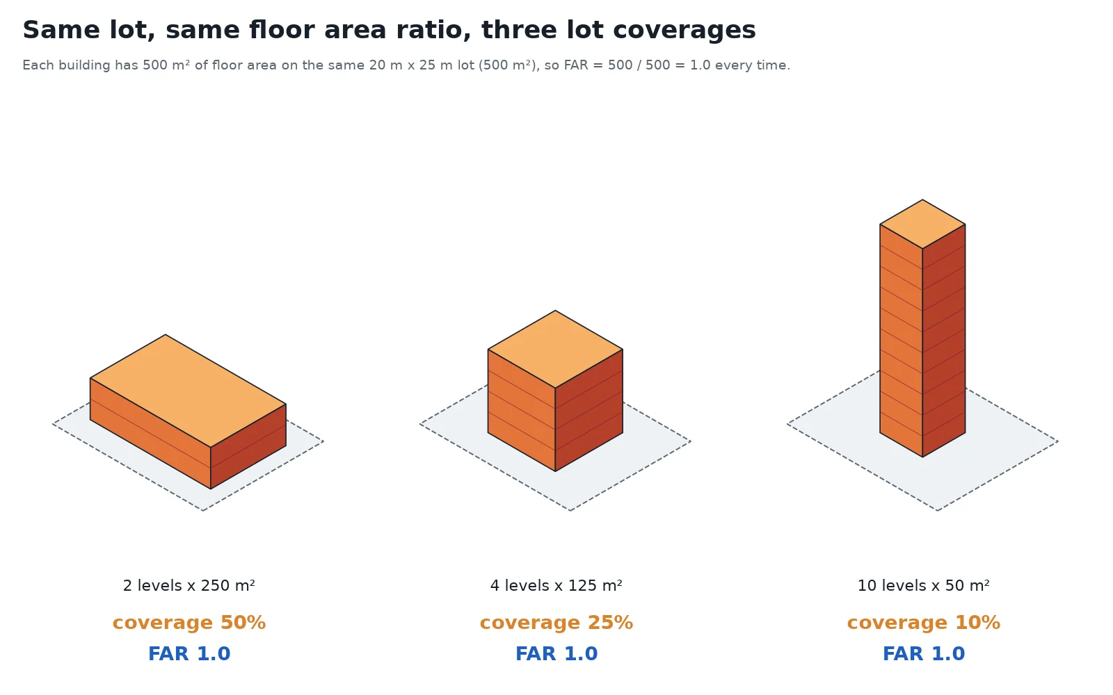
Here, 1.2 / 0.40 = 3 levels. If you keep the same 500 m² lot and cap the FAR at 1.0 (500 m² of total floor area), changing the lot coverage forces the height of the building to change in proportion:
| Option on a 500 m² lot | Footprint | Lot coverage | Levels | Gross floor area | FAR |
|---|---|---|---|---|---|
| Low and wide | 250 m² | 50% | 2 | 500 m² | 1.0 |
| Medium | 125 m² | 25% | 4 | 500 m² | 1.0 |
| Slender tower | 50 m² | 10% | 10 | 500 m² | 1.0 |
Now test the three-level, 600 m² building (40% coverage, FAR 1.2) against two real zoning rules:
- In a German residential zone (reines or allgemeines Wohngebiet), the national orientation values are a maximum coverage (GRZ) of 0.4 and a maximum floor area ratio (GFZ) of 1.2. The building sits right on both limits and passes.
- In a Japanese low-rise residential zone (第一種低層住居専用地域) where the city plan picked a 50% coverage cap (建ぺい率) and a 100% floor area cap (容積率), the 40% footprint passes the coverage check. The floor area fails: 100% of a 500 m² lot is 500 m², so your 600 m² building is 100 m² too big. You would have to trim one floor down to 100 m², or drop to two levels of 250 m².
How countries name and cap FAR and lot coverage
Every planning system controls these two ratios, under its own initials and legal codes.
| Country | Coverage term | FAR term | Where the rule lives | Example legal values |
|---|---|---|---|---|
| Japan | 建ぺい率 (建蔽率) = 建築面積 / 敷地面積 | 容積率 = 延べ面積 / 敷地面積 | Building Standards Act Art. 53 and Art. 52; values chosen per zone by the city plan | 建ぺい率 30% to 60% in low-rise residential zones, 80% in commercial; 容積率 50% to 200% in low-rise residential, up to 1,300% in commercial |
| Germany | Grundflächenzahl (GRZ) | Geschossflächenzahl (GFZ) | Baunutzungsverordnung (BauNVO) §19, §20, values in §17; set by each Bebauungsplan | Allgemeines Wohngebiet GRZ 0.4 / GFZ 1.2; Mischgebiet 0.6 / 1.2; urbanes Gebiet 0.8 / 3.0; Kerngebiet 1.0 / 3.0; Gewerbegebiet 0.8 / 2.4 |
| Brazil | Taxa de ocupação (TO) | Coeficiente de aproveitamento (CA) | Estatuto da Cidade (Lei 10.257/2001) art. 28; each city's plano diretor and zoning law | São Paulo: basic CA 1.0 citywide, maximum CA 4.0 along transit axes (ZEU); ZEU TO 0.85 on lots up to 500 m², 0.70 on larger lots |
| France | Coefficient d'emprise au sol (CES), from emprise au sol | COS (coefficient d'occupation des sols), abolished in 2014; floor area is surface de plancher | Code de l'urbanisme R420-1, R111-22, R151-39; loi ALUR 2014 art. 157 | Each plan local d'urbanisme (PLU) sets its own CES per zone; no national value |
| United States | Lot coverage | Floor area ratio (FAR) | Each city's zoning code; NYC Zoning Resolution §12-10 defines both | New York R10 district: max FAR 10.0 (12.0 with affordable or senior housing); R6 to R12 max residential coverage 80% interior, 100% corner |
| Indonesia | Koefisien dasar bangunan (KDB) | Koefisien lantai bangunan (KLB) | Peraturan Pemerintah 16/2021, Pasal 1; values set locally in the RDTR / KRK | Expressed as percentages; set by each local spatial plan, no national value |
Japan: 建ぺい率 and 容積率
Under the Building Standards Act (建築基準法), the city plan picks the coverage and the FAR of each zone from a menu the statute writes in tenths; zoning maps show them as percentages. Total floor area (延べ面積, commonly called 延床面積) is defined in Article 2(1)(iv) of the Enforcement Order (建築基準法施行令) as the sum of the floor areas of every floor of a building, and the same order excludes parking and some similar spaces when the 容積率 is checked.
Article 52(1) sets the options for 容積率 (FAR):
- Low-rise residential zones (第一種・第二種低層住居専用地域, 田園住居地域): 50%, 60%, 80%, 100%, 150% or 200% (5/10 to 20/10).
- Mid-rise and standard residential, neighbourhood commercial and quasi-industrial zones: 100% to 500% (10/10 to 50/10).
- Commercial zones (商業地域): 200% to 1,300% (20/10 to 130/10).
- Industrial zones: 100% to 400% (10/10 to 40/10).
Article 52(2) adds a second ceiling whenever the front road is narrower than 12 m: you multiply the road width in metres by 4/10 in residential zones and by 6/10 in the other zones (the authority can change these factors in designated areas), and the stricter of the zoned 容積率 and the road-width 容積率 applies. On a 4 m road in a low-rise residential zone, 4 × 4/10 = 160%; if the zone map says 100%, your cap is 100%, and if the zone map says 200%, the narrow road clips you down to 160%.
Article 53(1) sets 建ぺい率 (lot coverage) at 30%, 40%, 50% or 60% in low-rise and mid-rise residential zones, 50%, 60% or 80% in other residential zones, 60% or 80% in neighbourhood commercial zones, and 80% in commercial zones. Under Article 53(3), a parcel gets 10 points more for a designated corner lot, 10 more for a fire-resistive building in a fire prevention district, or 20 more when both apply. Under Article 53(6), a fire-resistive building in a fire prevention district inside a commercial zone has no coverage limit at all.
Germany: Grundflächenzahl (GRZ) and Geschossflächenzahl (GFZ)
Germany's federal Land Use Ordinance, the Baunutzungsverordnung (BauNVO), defines the Grundflächenzahl in §19 and the Geschossflächenzahl in §20. Both are decimals: a GRZ of 0.4 allows 0.4 m² of ground footprint per square metre of plot.
Under §19(4), the GRZ check also counts garages, parking spaces with their driveways (Zufahrten), ancillary structures and underground structures. Those surfaces are allowed to push the total coverage up to 50% above the base GRZ (for example from 0.4 up to 0.6), capped at a hard ceiling of 0.8 unless the local development plan (Bebauungsplan) sets a different rule.
Since the 2021 Baulandmobilisierungsgesetz, the table in §17 BauNVO gives orientation values (Orientierungswerte) for the upper limits rather than rigid ceilings:
| Zone type in §17 BauNVO | GRZ (lot coverage) | GFZ (floor area ratio) |
|---|---|---|
| Kleinsiedlungsgebiet (WS, smallholding area) | 0.2 | 0.4 |
| Reines and allgemeines Wohngebiet (WR, WA, residential) | 0.4 | 1.2 |
| Besonderes Wohngebiet (WB, special residential) | 0.6 | 1.6 |
| Dorfgebiet and Mischgebiet (MD, MI, village and mixed) | 0.6 | 1.2 |
| Urbanes Gebiet (MU, dense urban mixed) | 0.8 | 3.0 |
| Kerngebiet (MK, city core) | 1.0 | 3.0 |
| Gewerbegebiet and Industriegebiet (GE, GI, commercial and industrial) | 0.8 | 2.4 |
Brazil: taxa de ocupação (TO) and coeficiente de aproveitamento (CA)
Brazil's federal City Statute (Lei 10.257/2001, article 28) defines the coeficiente de aproveitamento as the ratio between buildable floor area and lot area, and splits it into a basic coefficient (free of charge to every landowner) and a maximum coefficient that developers can reach by paying the city a fee called the outorga onerosa do direito de construir.
In São Paulo, article 116 of the Strategic Master Plan (Lei 16.050/2014) sets the basic CA at 1.0 across the whole city and raises the maximum CA to 4.0 along the urban transit corridors (Eixos de Estruturação da Transformação Urbana). In the land-use law (Lei 16.402/2016, Quadro 3), those transit zones (ZEU) have a minimum CA of 0.5, a basic CA of 1.0 and a maximum CA of 4.0, paired with a maximum taxa de ocupação (TO) of 0.85 for lots up to 500 m² and 0.70 for lots of 500 m² or more.
France: emprise au sol, surface de plancher and the abolished COS
French zoning plans (plans locaux d'urbanisme, PLU) used to cap floor area with a ratio called the coefficient d'occupation des sols (COS). Article 157 of the loi ALUR of 24 March 2014 rewrote the article of the planning code that listed what a PLU may regulate, and left the COS out, along with the minimum lot size.
Today, a French PLU cannot set a maximum FAR directly. Instead, under article R151-39 of the Code de l'urbanisme, the PLU can set a maximum emprise au sol (defined in R420-1) and a maximum height, and it places buildings with setback rules. Together those rules set an implicit FAR ceiling. Floor area still matters: permit applications state the surface de plancher defined in article R111-22.
United States: local zoning codes
The United States has no national FAR table; each municipality defines both ratios in its zoning ordinance. In New York City, Zoning Resolution §12-10 defines floor area to the exterior face of the outside walls and lot coverage as the share of a zoning lot covered by buildings when viewed directly from above. In a high-density residential district such as R10, §23-22 sets a maximum residential FAR of 10.0, rising to 12.0 for qualifying affordable or senior housing, while §23-362 caps residential lot coverage in R6 through R12 districts at 80% on interior or through lots and 100% on corner lots.
Indonesia: KDB and KLB
In Indonesia, Government Regulation PP 16/2021 (Pasal 1, points 12 and 14) standardises the two ratios as percentages: koefisien dasar bangunan (KDB) is the percentage limit comparing total ground-floor area to the plot area, and koefisien lantai bangunan (KLB) is the percentage limit comparing total floor area of all levels to the plot area. The numeric caps are set locally, in the detailed spatial plan (Rencana Detail Tata Ruang, RDTR), and given for each plot in the city planning statement (Keterangan Rencana Kota, KRK).
How much do real parcels cover? 26,545 French parcels measured
Zoning codes tell you the legal maximum. They do not tell you what cities and suburbs look like on the ground. To get real numbers, I intersected every cadastral parcel with every building in four French places that span the whole density range: a central Paris arrondissement, an inner suburb next to Paris, a suburb of detached houses, and a rural village.
| Place | Settlement type | Built parcels | Median parcel | Lot coverage median (middle half) | Approx. FAR median (middle half) | Parcels above 40% coverage | Parcels above FAR 1.2 |
|---|---|---|---|---|---|---|---|
| Paris 11e arrondissement | Dense city centre | 4,389 | 313 m² | 86% (77% to 94%) | 4.9 (3.5 to 6.0) | 98% | 93% |
| Montreuil (Seine-Saint-Denis) | Inner suburb, bordering Paris | 11,801 | 232 m² | 49% (33% to 70%) | 0.92 (0.55 to 1.58) | 64% | 36% |
| Olivet (Loiret) | Suburb of detached houses | 8,346 | 548 m² | 23% (15% to 33%) | 0.33 (0.20 to 0.55) | 17% | 5% |
| Lussac-les-Châteaux (Vienne) | Village of about 2,300 people | 2,009 | 624 m² | 21% (11% to 47%) | 0.27 (0.13 to 0.67) | 29% | 10% |
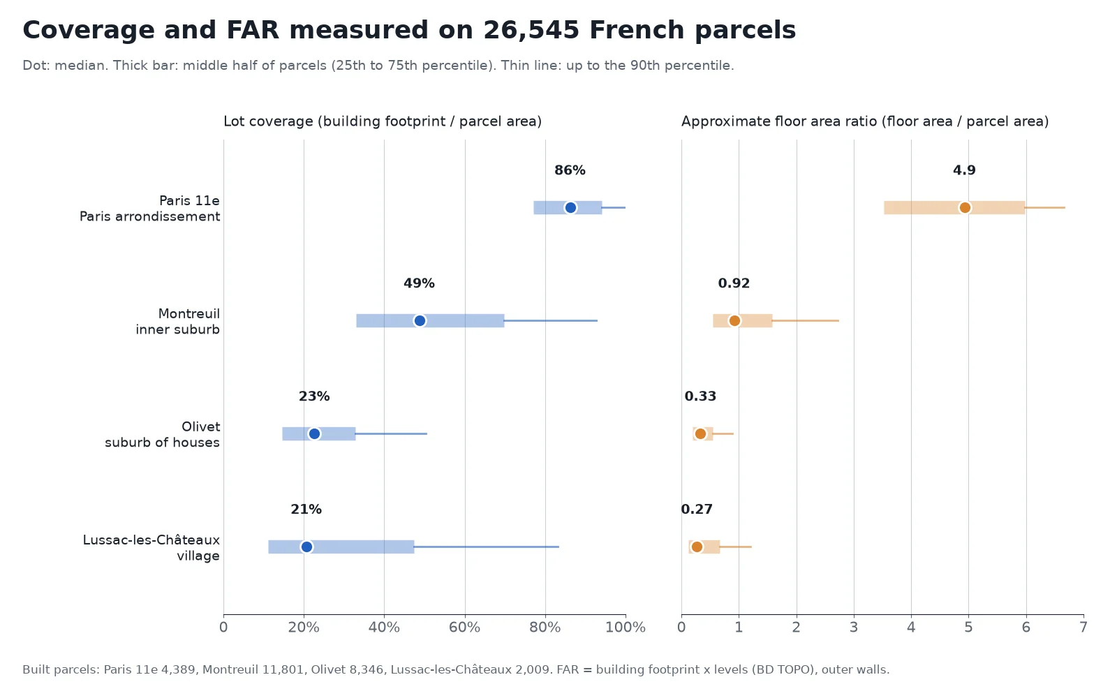
What the numbers show:
- Paris 11e is built to the courtyard wall. More than two thirds (68%) of its built parcels have over 80% of their ground covered by buildings, and 66% have an approximate FAR above 4.0. The 90th percentile reaches 99.8% coverage and a FAR of 6.7. Its median FAR of 4.9 sits well above the highest orientation value in the German BauNVO (3.0 for city cores and dense urban zones). Over the covered part of each parcel, the median ratio of FAR to coverage is 6.0 levels.
- Suburban houses sit far below standard residential caps. In Olivet, the median built parcel covers 23% of its 548 m² lot and reaches an approximate FAR of 0.33, with a median of 1.8 levels over the footprint. Only 17% of Olivet's built parcels exceed a 40% coverage limit, and only 5% exceed a FAR of 1.2. That 23% all-parcel median matches the 23% median we measured on single-house lots in our building footprint guide.
- A rural village spreads wider than a suburb. Lussac-les-Châteaux has a lower median FAR than Olivet (0.27 vs 0.33, with a median of 1.0 level over the footprint because of barns, sheds and one-level houses), yet 29% of its built parcels exceed 40% coverage and a tenth exceed 83%. Its old centre packs small, fully built plots, while a quarter of its built parcels, gardens and farm plots, are less than 11% covered.
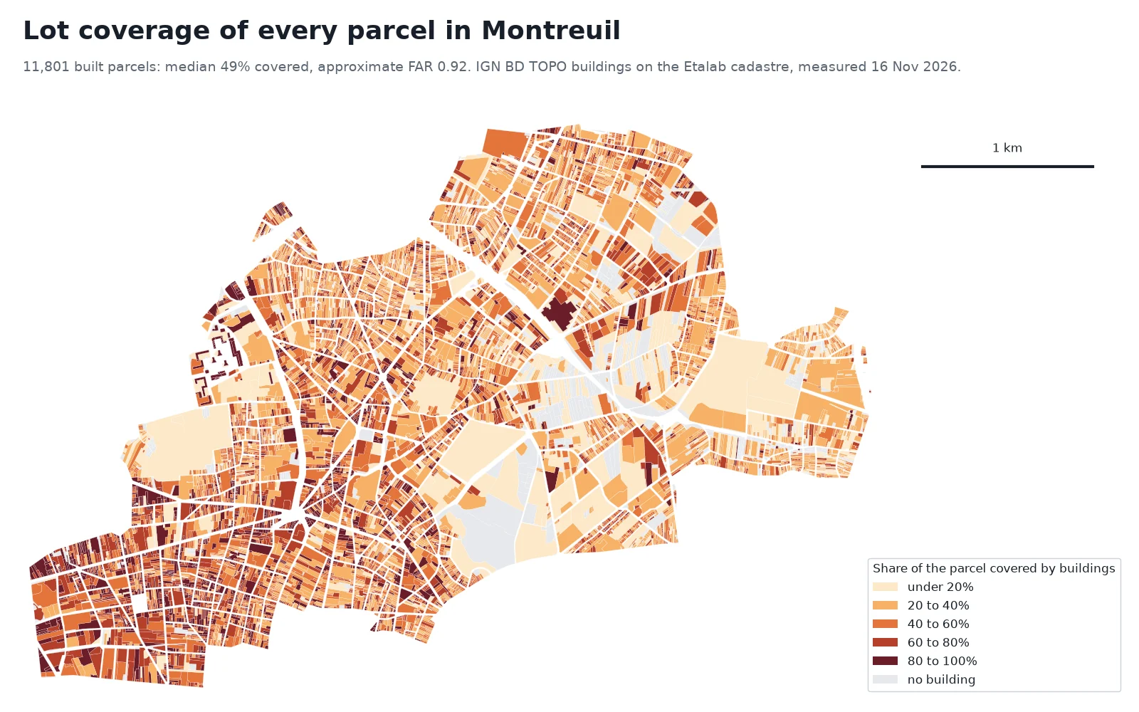
If you sum all built parcel land together instead of taking the median parcel, the area-weighted averages come out lower: 72% coverage and FAR 4.1 in Paris 11e, 40% and 1.26 in Montreuil, 18% and 0.31 in Olivet, and 9% and 0.13 in Lussac-les-Châteaux. Large parcels such as schools, parks with a pavilion, industrial yards and farmsteads keep a lot of open ground, which pulls the area-weighted ratio down while barely moving the parcel median.
How we measured this
On 16 November 2026, I pulled every cadastral parcel from the Etalab cadastre (edition of 1 September 2026) and every in-service building from IGN's BD TOPO (edition of 15 September 2026, via the keyless Géoplateforme WFS), projected to Lambert-93 (EPSG:2154). Across the four communes there are 40,279 parcels of 20 m² or more. I counted a parcel as built when at least 10 m² of building footprint fell inside its boundary: 97% of parcels in Paris 11e are built, 86% in Montreuil, 50% in Olivet and 36% in Lussac-les-Châteaux, for a total of 26,545 built parcels. Only built parcels enter the medians above.
Lot coverage is the geometric union of all BD TOPO building outlines clipped to the parcel, divided by the parcel area. That includes detached garages, garden sheds and annexes, just as French emprise au sol does. Approximate FAR is the sum, over each building piece inside the parcel, of its footprint area multiplied by its number of levels, divided by the parcel area.
The number of levels comes from BD TOPO's nombre_d_etages attribute (taken from the land tax files, which count the ground floor and exclude basements). That field supplies 82% of the built footprint area in Paris 11e, 65% in Montreuil, 66% in Olivet and 62% in Lussac-les-Châteaux. Where nombre_d_etages is missing, I estimated the levels by dividing the building's hauteur (height to the roof gutter) by 3.07 m, the median story height we measured on 243,603 buildings in our guide on how tall a story is, rounded to at least 1 level (17% to 38% of built area). When both fields were empty, I defaulted to 1 level (0.2% to 3% of built area).
Four limits apply to these numbers:
- Four communes show the spread across settlement types, not a national average for France.
- BD TOPO traces some buildings from aerial imagery around the roof edge, which slightly overstates the ground footprint when a roof overhangs the walls.
- Cadastre parcels and BD TOPO buildings are maintained separately, so wall lines and parcel lines can shift by a few centimetres; where a building fills an entire tiny plot, coverage is capped at 100%.
- Multiplying outer-wall footprint by levels gives an external gross floor area. It does not deduct wall thickness, stairs, garages or low-ceiling attics, and it ignores underground basements, so it is an external physical FAR rather than a legal French surface de plancher.
How to calculate FAR and lot coverage for your own lot
For a lot in France you can get every input from our free tools; elsewhere, the building outlines still come from open data and the parcel from your local cadastre or survey.
Get the parcel and its area
Find the plot with the cadastral parcel tool by address, cadastral reference or a click on the map. It gives the recorded area and the area drawn on the plan, which often differ by a few percent, and exports the outline as GeoJSON, KML, DXF or Shapefile.
Get the building outlines
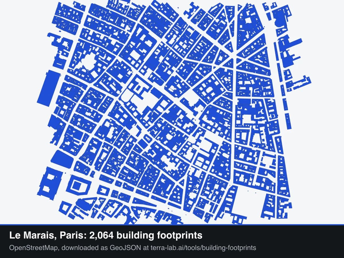
Draw a box around the lot in the building footprints tool and download the polygons from OpenStreetMap, Microsoft or Google Open Buildings as GeoJSON. Keep every building inside the parcel, garage and shed included, and add up their areas measured in a metric CRS: that sum divided by the lot area is the lot coverage.
Get the number of levels
Click each building on the building height map to read its height in metres and its number of floors from IGN BD TOPO (France). With a height only, divide it by about 3 m (10 ft) per story.
Multiply, add, divide
Multiply each footprint by its number of levels, add the buildings together and divide by the lot area: that is the approximate FAR. For a permit, recompute the floor area with the measuring line and deductions of your local code.
For thousands of parcels, do it in QGIS: run Vector > Geoprocessing Tools > Intersection between the parcel layer and the building layer in a projected CRS, compute $area and $area * coalesce("nombre_d_etages", 1) on the pieces, then sum them per parcel ID with the Aggregate algorithm and divide by the parcel area.
 : run Vector > Geoprocessing Tools > Intersection between the parcel layer and the building layer in a projected CRS, compute
We build AI Agent, a QGIS plugin that runs QGIS processing from a plain-language request, for example intersecting a parcel layer with a building layer and adding a coverage field to every parcel.
Questions people ask
There is no single good floor area ratio because the number describes density, which depends on the zone. In our measurement of 26,545 French parcels, median FAR is 0.27 in a village, 0.33 in a detached-house suburb, 0.92 in an inner suburb and 4.9 in central Paris. In zoning laws, caps run from 0.5 in Japan's strictest low-rise residential zones to 13.0 in its densest commercial zones, and New York's R10 district allows 10.0.
Add up the gross floor area of every floor of every building on the parcel, then divide that total by the area of the parcel. For example, a 3-story building with 200 m² on each floor has 600 m² of gross floor area; on a 500 m² lot, its floor area ratio is 600 / 500 = 1.2 (or 120%). To work backwards from a zoning limit, multiply the allowed FAR by your lot area to find the maximum floor area you can build.
Lot coverage only measures the ground floor footprint divided by the lot area, while floor area ratio sums every story of the building and divides by the lot area. A one-story building covering half the lot and a two-story building covering a quarter of the lot both have a FAR of 0.5, but their lot coverages are 50% and 25%. For a building with identical floors, FAR divided by lot coverage equals the number of stories.
It depends on the local code, so read its definition of coverage or footprint. In France, emprise au sol (article R420-1) is the vertical projection of the building with its overhangs, so a balcony or roof held up by posts counts, while unsupported roof eaves and ornaments do not. In Germany, BauNVO §19(4) requires garages, parking spaces and their driveways to be counted in a second check, allowing them to exceed the base GRZ by up to 50% (up to a ceiling of 0.8).
Under Germany's Baunutzungsverordnung (BauNVO), the Grundflächenzahl (GRZ, §19) is the maximum lot coverage and the Geschossflächenzahl (GFZ, §20) is the maximum floor area ratio across all full storeys (Vollgeschosse). Both are written as decimals: in a standard residential zone (allgemeines Wohngebiet, §17), the orientation values are a GRZ of 0.4 (40% of the plot covered) and a GFZ of 1.2 (floor area equal to 120% of the plot area).
Many zoning codes, including the New York City Zoning Resolution (§12-10) and Germany's BauNVO (§20), measure gross floor area to the outside face of the exterior walls. By contrast, the International Building Code (§202) and France's surface de plancher (Code de l'urbanisme R111-22) measure from the inside face of the exterior walls, and France also deducts stair openings, parking and areas with 1.80 m of ceiling height or less. On a 10 m by 10 m house with 30 cm walls, the two lines give 100 m² and 88.4 m² per level.
Do it in QGIS by asking for it
AI Agent carries out the task you describe, in your own QGIS project. Free, no card.