QGIS on Mac: Apple Silicon, Install and Fixes (2026)
Published
Yes, QGIS runs natively on a Mac in 2026, on Apple Silicon and on Intel. The official installer from qgis.org/download is one file for both: the app inside is a universal binary that holds an arm64 build and an x86_64 build, so an M1 to M4 Mac does not go through Rosetta. I checked it on my own MacBook (Apple M4, 16 GB, macOS 27.0.1) on 12 November 2026: QGIS 3.44.15 reports arm64 as its running architecture.
 runs natively on a Mac in 2026, on Apple Silicon and on Intel. The official installer from
Which file to take: the Long Term Release, 3.44.15, if you want the version that changes least, or the Latest Release, 4.2.3, if you want QGIS 4. Both are about 1.6 GB to download and about 3.5 GB once installed.
The rest of this page gives the install steps, the numbers I measured, the four things that are rough on macOS with their fix, and the plugins I would add first. If you are on Windows or Linux, the general guide is how to download and install QGIS. If you have never opened the software, start with what QGIS is.
Which QGIS download for Mac: LTR or latest
The download page lists two macOS installers on 12 November 2026. I read their size and date from the server without downloading them.
| Long Term Release | Latest Release | |
|---|---|---|
| Version | 3.44.15 "Solothurn" | 4.2.3 "Belém do Pará" |
| File | qgis_ltr_final-3_44_15.dmg | qgis_pr_final-4_2_3.dmg |
| Download size | 1.55 GB | 1.59 GB |
| File dated | 28 September 2026 | 28 September 2026 |
| Size in Applications (measured) | 3.4 GB | 3.6 GB |
| Architectures in the app (measured) | arm64 and x86_64 | arm64 and x86_64 |
| App name once installed | QGIS.app | QGIS-final-4_2_3.app |
The QGIS project's own advice on that page is short: "If you are unsure which version is best for you, download the LTR." I agree for a first install. Take 4.2 when you need a QGIS 4 feature or when a colleague sends you projects saved in QGIS 4. Plugins are the other reason to check first: most have a version listed for QGIS 4, some do not, and I keep the count for AI plugins in QGIS 4 AI plugins.
About the system requirement, the installation guide says the installers "are compatible with High Sierra (10.14) and newer for Intel x64 and Apple silicon (ARM) devices". High Sierra is macOS 10.13 and 10.14 is Mojave, so the floor is one of the two, and any Mac kept up to date since 2018 is covered. The page gives no memory figure. On my 16 GB Mac, QGIS shares memory with a browser and a code editor without trouble on city-sized data.
How to install QGIS on a Mac
Download the DMG from qgis.org
Open qgis.org/download, choose macOS, then Long Term Release or Latest Release. The page describes them as "Official All-in-one, signed and notarized installers for macOS". Take the file from qgis.org only, not from a download directory that repackages an old version.
Drag QGIS into Applications
Open the DMG and drag the QGIS icon onto the Applications folder. There is no installer to click through and no separate GDAL or Python to install first: both are inside the app.
Open it once from Applications
Double-click QGIS in Applications. macOS checks the app on first launch, which takes longer than every launch after it, then asks you to confirm that you want to open an app downloaded from the internet. Click Open.
Add a basemap to check that it works
In the Browser panel, open XYZ Tiles and double-click OpenStreetMap. If a street map appears, the install is done.
I did not reinstall QGIS for this article, so the steps above are the official ones and the launch dialog is described from Apple's documentation, not from a capture. What I did measure is everything after the install, below.
"QGIS cannot be opened": the Gatekeeper message
Gatekeeper is the part of macOS that blocks apps it cannot verify. The current official installers are signed and notarized, so they should pass with the simple "downloaded from the internet" confirmation. You can still meet a harder block, "QGIS cannot be opened because Apple cannot check it for malicious software", with an older installer, a nightly build or a copy from another site.
The way around it is Apple's own, described in Open a Mac app from an unknown developer:
- Try to open QGIS once and dismiss the message.
- Open System Settings > Privacy & Security and scroll to Security.
- Click Open Anyway next to the line about QGIS, then confirm with your password or Touch ID.
Since macOS Sequoia, Control-click then Open no longer skips this step, so old tutorials that tell you to right-click will not work. Use this override only for a file you downloaded from qgis.org yourself.
What I measured on an M4 MacBook
| Measure | Result |
|---|---|
| Mac | Apple M4, 16 GB, macOS 27.0.1 |
| QGIS | 3.44.15 "Solothurn" (and 4.2.3 installed next to it) |
| Running architecture | arm64 (native, no Rosetta) |
| App size | 3.4 GB for 3.44.15, 3.6 GB for 4.2.3 |
| Bundled Python | 3.12.11, with pip 26.2.1 |
| Bundled GDAL | 3.13.3, 202 raster and vector drivers |
| Qt | 5.15.19 in 3.44, device pixel ratio 2.0 (Retina) |
| Processing algorithms available | 475 |
| New profile, launch to ready | about 7 seconds |
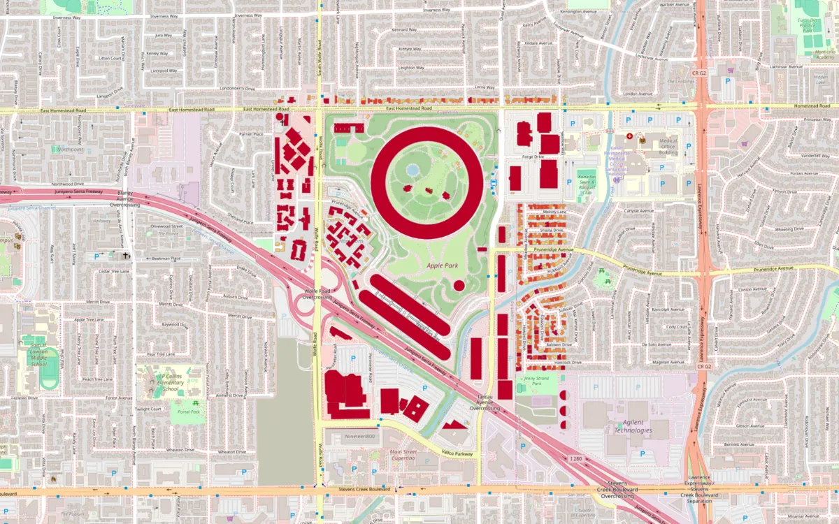
| 440 OpenStreetMap buildings fetched and styled by AI Agent | 21 seconds |
Two notes on that table. The 7 seconds is the time for a brand-new user profile to start and answer a first command, with other apps open, and a profile loaded with many plugins starts slower. The 475 algorithms include three plugin providers on my install, so a clean install shows fewer.
What is rough on macOS, and the fix
Most of QGIS behaves the same on a Mac as on Windows. These four points are where it does not.
1. Plugins that need extra Python packages
Some plugins need a Python package that QGIS does not ship, and their error message says No module named .... On a Mac, the Python that matters is the one inside the app, not the one from Homebrew or from python.org. Installing the package with your Terminal's usual pip puts it where QGIS never looks.
I checked how the bundled Python behaves. Called directly from Terminal, /Applications/QGIS.app/Contents/MacOS/python3.12 stops with "Could not find platform independent libraries". It works once you tell it where its home is:
PYTHONHOME=/Applications/QGIS.app/Contents/Frameworks \
  /Applications/QGIS.app/Contents/MacOS/python3.12 -m pip install --user <package>
With --user, the package lands in ~/.local/lib/python3.12/site-packages, a folder that is on QGIS's Python path on my Mac. It also survives a QGIS update, because it lives outside the app. Restart QGIS afterwards. I ran the command above up to pip --version and did not install a new package for this article.
Well-made plugins spare you all of this by installing their own dependencies on first run.
2. Formats the Mac build does not open
The bundled GDAL has 202 drivers, and the common ones are there: GeoPackage, Shapefile, GeoJSON, KML, DXF, GeoTIFF and COG, GeoParquet, NetCDF, PostGIS, and OpenFileGDB for Esri file geodatabases. Four that people ask about are missing on my install:
| Format | Driver in the Mac build | What to do |
|---|---|---|
| DWG (AutoCAD) | No | Export DXF from the CAD tool, or convert first |
| ECW | No | Ask for GeoTIFF or COG |
| MrSID | No | Ask for GeoTIFF or JPEG 2000 |
| FileGDB (Esri's own SDK driver) | No | OpenFileGDB reads and writes .gdb |
So when a .dwg or .ecw refuses to load, the file is fine and the driver is absent. Check your own install in Settings > Options > GDAL.
3. Two versions side by side
The LTR installs as QGIS.app and 4.2.3 as QGIS-final-4_2_3.app, so both sit in Applications without overwriting each other. I run both. They also keep separate settings: QGIS 3 profiles live in ~/Library/Application Support/QGIS/QGIS3 and QGIS 4 profiles in ~/Library/Application Support/QGIS/QGIS4, so your plugins and toolbars in one do not follow you into the other. Count 7 GB of disk for the pair.
A project saved in QGIS 4 may not open cleanly in 3.44. Keep a copy before you open an old project in the new version.
4. Uninstalling, or starting clean
Drag the app from Applications to the Trash. That removes the 3.4 GB app and leaves your settings and plugins, which is what you want before an update. For a full reset, also delete the QGIS3 or QGIS4 folder named above. My default profile weighs 4.9 GB, so it is worth a look when disk space is short.
Before you delete everything, try a new profile instead: Settings > User Profiles > New Profile gives you a clean QGIS in seconds and tells you whether a plugin was the cause of your problem.
Homebrew, MacPorts and conda
The official installer is the route I use and the only one I tested. The others exist, and here is what their own pages say.
| Route | What it installs | Status here |
|---|---|---|
| Official DMG | 3.44.15 LTR or 4.2.3, universal | Tested |
| Homebrew cask | brew install --cask qgis gives 4.2.3, qgis@ltr gives 3.44.15: the same official app | Read from brew info, not installed |
| MacPorts | Ports qgis3 and qgis3-ltr, built for your architecture, in /Applications/MacPorts/QGIS3.app | Read from the QGIS guide, not tested |
| conda-forge | A qgis package inside a conda environment | Not tested |
One warning from the QGIS installation guide: Homebrew and MacPorts on the same Mac "will almost certainly lead to conflicts". Pick one.
Plugins that work on a Mac
Plugins are installed from Plugins > Manage and Install Plugins, the same way on every system. These are the ones I add first on a new Mac, all running here on Apple Silicon.
1. QuickMapServices, for basemaps
It adds a menu of ready-made background maps, so you do not paste tile URLs by hand. The steps and the terms of use of each source are in how to add a basemap in QGIS.
2. AI Agent, to ask for the map in a sentence
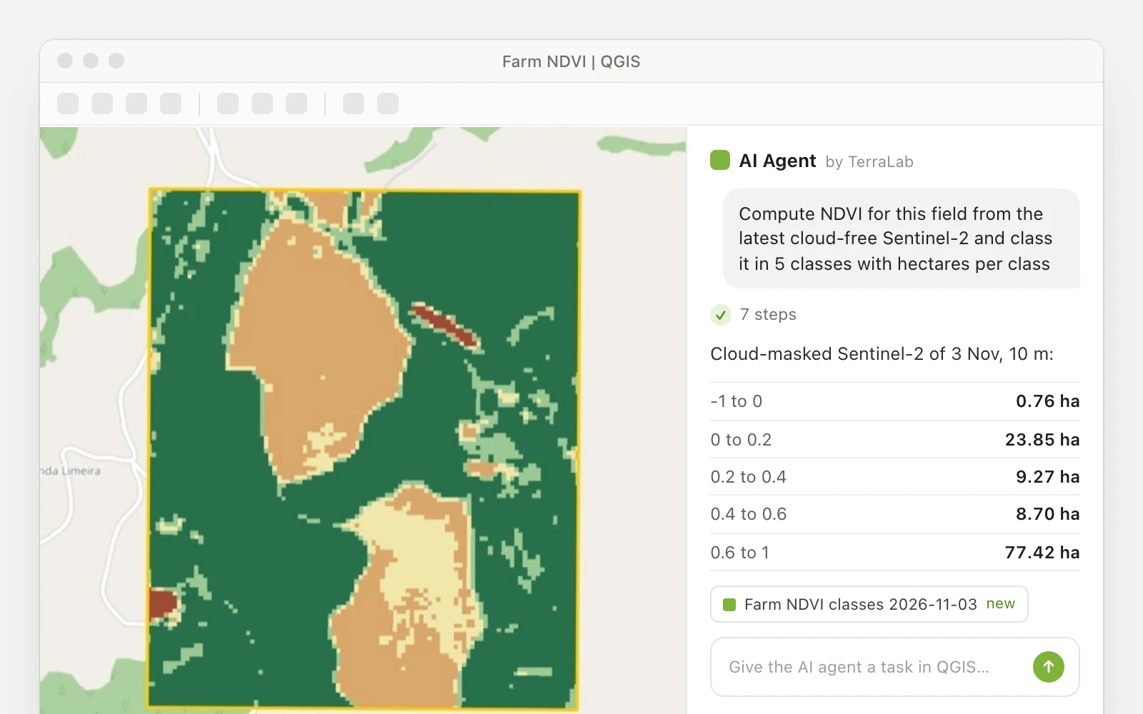
AI Agent is our plugin: a chat panel inside QGIS that runs the tools for you. You describe the result, it fetches the data, runs the processing and styles the layer, and every step stays visible and undoable.
I ran one request on the M4 for this article, on an empty project with only an OpenStreetMap basemap.
By hand, the same map takes QuickOSM, the Field Calculator and the Symbology panel, which is a good exercise once and slow the tenth time. The limits are plain: the AI Agent needs an internet connection, the free plan covers a monthly allowance of messages, and you should read the answer before trusting a number in it. The full walkthrough is in the AI Agent guide.
3. QuickOSM, for OpenStreetMap data
It downloads roads, buildings or any tagged object for an area. See download OSM data in QGIS for the queries that work.
For a longer list by task, see the best QGIS plugins. And if this is your first hour in the software, the QGIS tutorial for beginners builds a first map step by step, with or without AI Agent.
What to remember
- One official installer covers Apple Silicon and Intel, and it runs natively on both.
- Take the LTR (3.44.15) unless you need QGIS 4 (4.2.3). Both can live side by side.
- Plan 1.6 GB to download and 3.5 GB installed per version.
- Python packages for plugins go through the Python inside QGIS.app, not your system one.
- DWG, ECW and MrSID do not open in the Mac build. Ask for DXF or GeoTIFF.
Questions people ask
Yes. The official installers for QGIS 3.44 and 4.2 contain a universal app with a native arm64 build. On an Apple M4, QGIS 3.44.15 reports arm64 as its architecture and does not use Rosetta.
Yes. QGIS is free and open source on every system, with no paid edition and no license key. Download it from qgis.org. Some plugins made by companies have paid plans, and the software itself never does.
The QGIS installation guide states that the macOS installers are compatible with "High Sierra (10.14) and newer" on Intel x64 and Apple Silicon. It gives no memory figure. Plan about 1.6 GB for the download and 3.5 GB of disk for the app. We measured only on a 16 GB Mac, where city-sized data is comfortable.
Gatekeeper blocked an app it could not verify, usually an old installer or a copy from another site. Download the current installer from qgis.org, which is signed and notarized. If the message persists, open System Settings > Privacy & Security and click Open Anyway next to the QGIS line.
Yes. brew install --cask qgis installs the latest release (4.2.3 on 12 November 2026) and brew install --cask qgis@ltr installs the long term release (3.44.15). Both casks install the official app. We read this from brew info and did not install through Homebrew.
On a Mac the question is simpler than elsewhere, because ArcGIS Pro has no macOS version and QGIS runs natively. For the features, costs and file formats of each, see our QGIS vs ArcGIS comparison.
Read nextWhat Is QGIS? Free GIS Software, QGIS 4, and the 10 Top Plugins
Do it in QGIS by asking for it
AI Agent carries out the task you describe, in your own QGIS project. Free, no card.