QGIS vs ArcGIS Pro in 2026: Price, Features, AI
Published
Pick QGIS if you want free GIS software that runs on Windows, macOS and Linux and handles everyday mapping, editing and analysis. Pick ArcGIS Pro if your organisation already runs on Esri's online platform, needs its specialist 3D or utility network tools, or wants a support contract. ArcGIS Pro costs $700 to $4,200 per user per year in the US. QGIS costs nothing.
Most comparisons online were written for QGIS 3 or earlier. This one is dated 26 September 2026: QGIS 4 has been out since March, and Esri has added a wave of AI assistants. I build QGIS plugins for a living, including AI Agent, an assistant that runs QGIS tasks for you, so I have a side. I've kept every place where ArcGIS is clearly ahead.
Quick verdict
- Freelancer or small firm: QGIS. No licence cost, and client files in Esri formats open fine.
- Organisation already on ArcGIS Online: ArcGIS Pro. It comes with the licences you already pay for.
- 3D, utility networks and land parcel records: ArcGIS Pro. These tools are mature and built in.
- Mac or Linux: QGIS. ArcGIS Pro runs on Windows only.
- AI without a powerful graphics card: QGIS with cloud plugins. ArcGIS's image AI needs an NVIDIA graphics card and a higher licence.
Compared at a glance
| QGIS | ArcGIS Pro | |
|---|---|---|
| Price | Free | $700, $2,200 or $4,200 per user per year |
| Runs on | Windows, macOS, Linux | Windows only |
| Add-ons | 3,600 free plugins | Esri extensions at $650 a year each |
| Support | Community, or paid from independent firms | Esri support included |
| Online maps | QGIS Server, web exports, QField for phones | ArcGIS Online, closely built in |
| AI | Plugins, some free, some cloud-based | 100+ image models, AI assistants mostly in beta |
How I compared them
On 26 September 2026 I read Esri's US store and documentation, and QGIS's release notes and plugin repository. I took every screenshot in QGIS 4. I compared what a working GIS professional pays and gets: cost over three years, systems it runs on, tools in the box, opening the other side's files, and AI. I don't run an ArcGIS Pro licence today, so the ArcGIS side comes from Esri's own pages, with links.
What each one costs
Esri sells ArcGIS Pro as a yearly licence, in three levels:
| Esri licence | ArcGIS Pro level | US price per year | What it adds |
|---|---|---|---|
| Creator | Basic | $700 | Mapping, editing and analysis |
| Professional | Standard | $2,200 | Advanced editing, data quality, utility networks |
| Professional Plus | Advanced | $4,200 | 3D, imagery, network and spatial analysis extensions |
| Personal Use | Basic | $100 | Non-commercial use only |
| Student Use | Advanced | $100 | Students only |
Each licence includes 500 ArcGIS Online credits a year, a prepaid allowance for cloud work such as address search. Extra extensions cost $650 a year each. Prices differ outside the US: the UK Creator price was £1,000 in 2024.
Over three years, the gap becomes a budget line:
| 1 user, 3 years | 3 users, 3 years | |
|---|---|---|
| QGIS | $0 | $0 |
| ArcGIS Pro Basic | $2,100 | $6,300 |
| ArcGIS Pro Standard | $6,600 | $19,800 |
| ArcGIS Pro Advanced | $12,600 | $37,800 |
QGIS still has costs: time to learn it, and a support contract if you need one. But that's a choice, and it doesn't grow with every person you hire.
Computer and system
ArcGIS Pro runs only on Windows. Esri recommends 32 GB of memory and a separate graphics card, and its image AI tools need an NVIDIA card with at least 4 GB of video memory. On a Mac, you run it inside Windows in a virtual machine or in the cloud.
QGIS runs directly on Windows, macOS and Linux, and a laptop from 2020 handles most everyday work.
Features compared
For the work most GIS professionals do every day, the two are level. The differences are at the edges.
| Task | QGIS | ArcGIS Pro |
|---|---|---|
| Editing shapes on the map | Yes | Yes |
| Printed maps | Yes, including map series | Yes, with a slightly smoother designer |
| Analysis tools | 462 built in, plus 307 from GRASS, and a visual model builder | Hundreds, plus ModelBuilder |
| 3D | 3D views and point clouds, lighter tools | Mature 3D editing and analysis |
| Road network analysis | Shortest paths, travel areas, plugins | Network Analyst, more complete |
| Utility networks, land parcel records | Not built in | Built in, Standard and up |
| Automation | Python (PyQGIS) | Python (ArcPy) |
| Online maps | QGIS Server, qgis2web, Lizmap | ArcGIS Online and Enterprise |
| Field data on phones | QField | Field Maps, Survey123 |
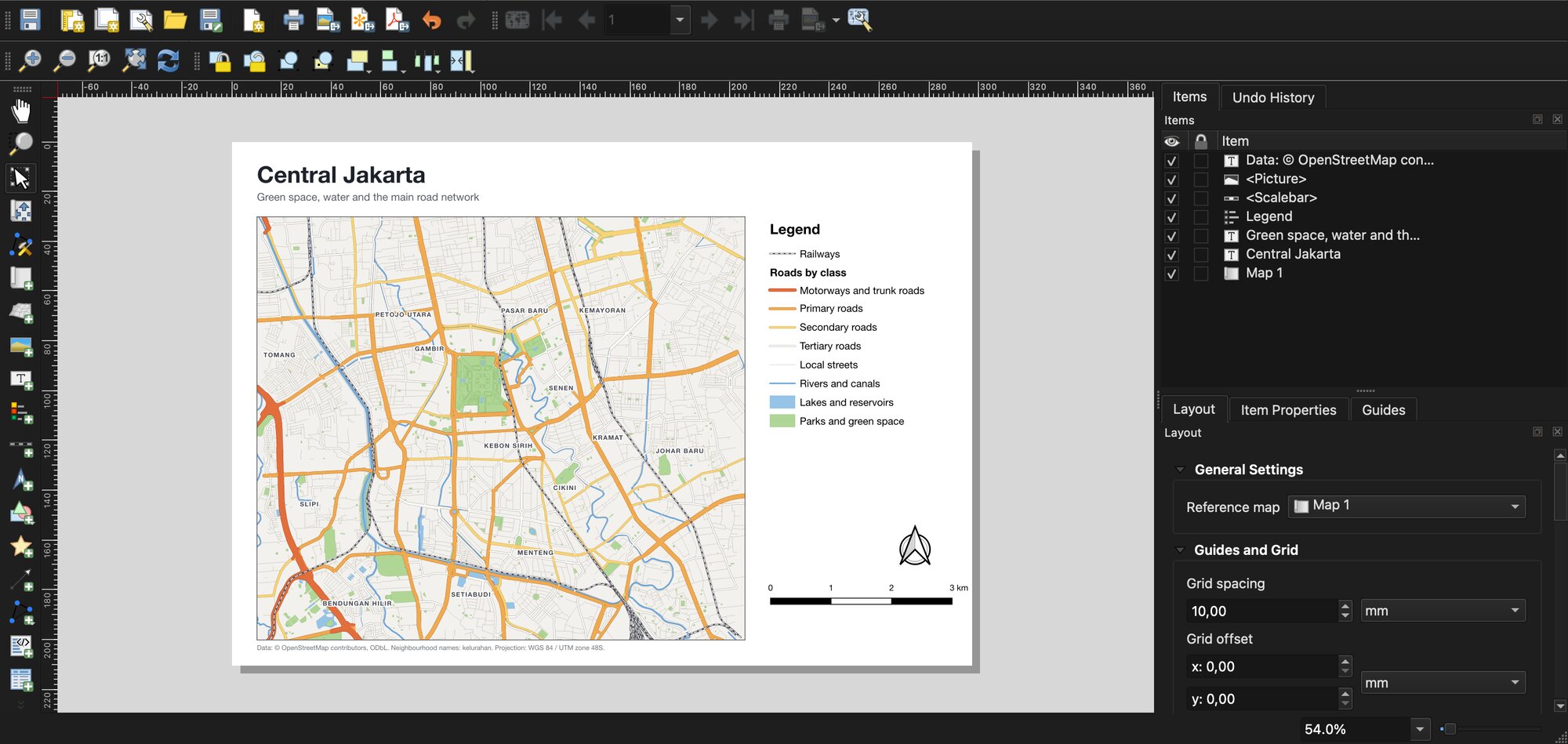
Printed maps are a good example of "level". QGIS has a full page designer with legend, scale bar, north arrow and map series, for any number of pages.
ArcGIS's ModelBuilder has a QGIS twin too. The Graphical Modeler chains tools into a reusable model by drawing boxes and arrows, with the tools from QGIS, GDAL and GRASS side by side.
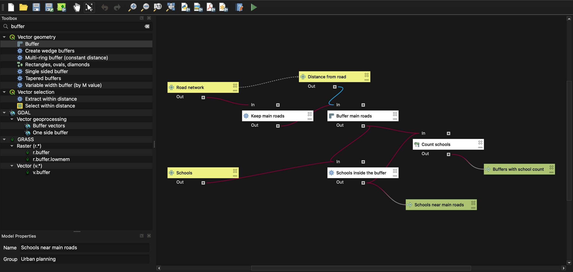
How we measured this. On 26 September 2026 we counted the tools registered in QGIS 4.0.0 on macOS: 462 from QGIS, GDAL and the point cloud engine, and 307 more from GRASS. On the macOS package we tested, GRASS itself was not included, so those 307 need a separate install.
The honest summary: if your job is mapping, analysis and preparing data, QGIS does it. If your job depends on Esri's company-wide setup, such as utility networks, land parcel records or a city-wide ArcGIS Online portal, ArcGIS Pro fits better.
Working with Esri files in QGIS
Most freelancers who choose QGIS still receive ArcGIS data. Most of it opens fine.
| Esri format | In QGIS |
|---|---|
| Shapefile | Opens and saves |
File geodatabase (.gdb) | Opens, and saves since QGIS 3.28 |
| ArcGIS online map services | Connect from the Browser panel, no Esri software needed |
Style files (.lyr, .lyrx) | Free SLYR Community plugin for basic conversion |
Project files (.mxd, .aprx) | Paid SLYR edition from North Road |
To test the service connection, I loaded the city of Bonn's street tree register straight from Esri's cloud. QGIS read all 65,663 trees, with no Esri software installed.
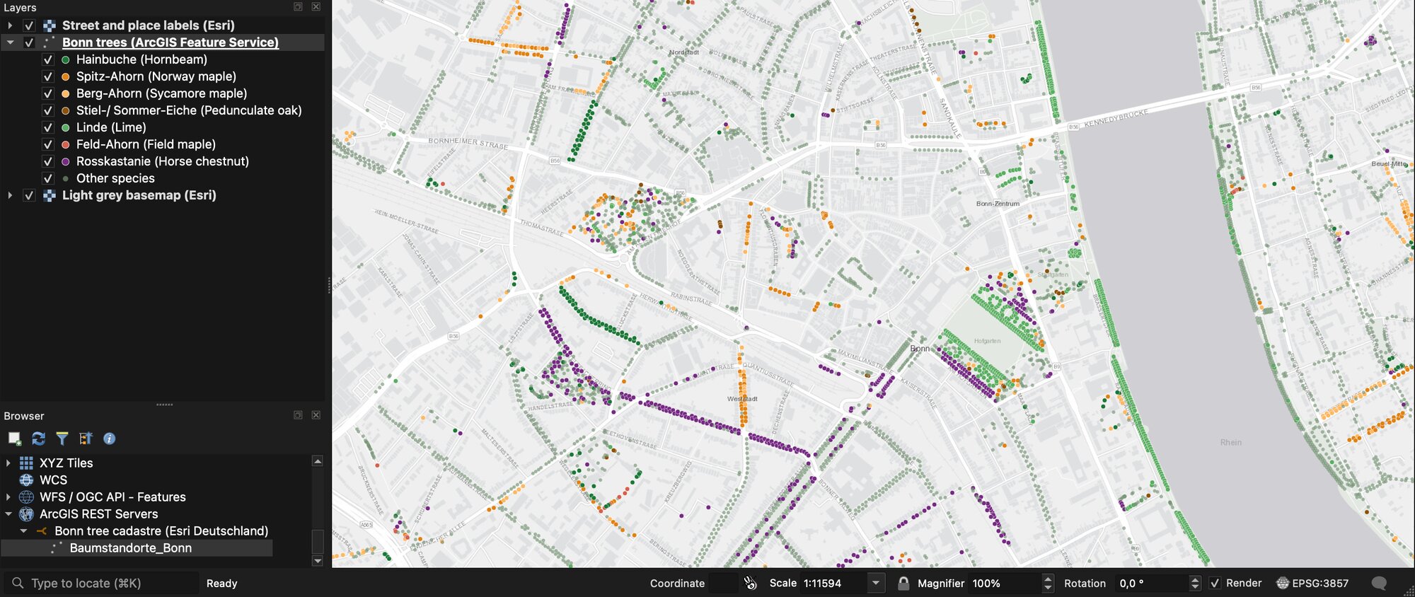
How we measured this. The layer is the Stadt Bonn tree cadastre, published under CC0 as an ArcGIS Feature Service by Esri Deutschland, with data dated February 2018. The 65,663 count comes from the service itself. The most common species is hornbeam, with 5,143 trees.
One thing to watch: on a QGIS older than 3.28, a file geodatabase may open read-only without much warning. On any recent version, you can create, edit and save them.
AI: where the gap moved in 2026
Esri offers two kinds of AI, and most comparisons mix them up.
Image AI. Esri has a library of over 100 ready-made models that find buildings, trees, roads or solar panels in images. They need a Professional licence or higher, an extra install and, in practice, an NVIDIA graphics card.
AI assistants. These are chat helpers inside Esri apps. In June 2026, Esri made three of them fully available (Survey123, Business Analyst and translation). Others, including the ArcGIS Pro assistant, are still in beta.
QGIS has no official AI. It has plugins, which means more choice and more variation in quality:
- Reading images. Free tools such as Qiusheng Wu's GeoAI plugin run the models on your own graphics card. Cloud plugins run them on a server, so a normal laptop works. What is GeoAI explains how.
- Doing the work. We counted 38 assistant and agent plugins in the official repository in September 2026: chat panels that run QGIS tools from a plain-language request. AI agents in QGIS has the full list.
An assistant that works in QGIS today
We build AI Agent, so this section is about our own plugin. Where the ArcGIS Pro assistant is still in beta, AI Agent is a released QGIS plugin you can install now. You type a task in a panel next to your map, and it finds the data, runs the QGIS tools and shows every step.
It runs on Windows, macOS and Linux, needs no graphics card, and includes the AI model, so there's no key to set up. It asks before deleting anything, and one click undoes a whole message. There's a free plan with no card needed, and Pro costs 49 EUR a month.
Try AI Agent free in QGIS, no card needed
Where the web gets this wrong
"ArcGIS Pro costs $100 to $700 a month." One top-ranking comparison still says this. Esri sells ArcGIS Pro per year, $700 to $4,200 in the US. $100 a year is the price of the non-commercial Personal Use licence.
"QGIS can't edit file geodatabases." It can, since QGIS 3.28. This was true of older versions and is still repeated.
"QGIS has about 300 plugins." The official repository listed 3,600 on 26 September 2026, 38% of them already marked ready for QGIS 4.
Which one should you choose?
| Your situation | Choose |
|---|---|
| Freelancer or small consultancy | QGIS |
| Public body already on ArcGIS Online | ArcGIS Pro |
| University teaching GIS on mixed laptops | QGIS, plus Student Use where a course needs ArcGIS |
| Utility, telecom or land registry on Esri network models | ArcGIS Pro |
| Mac or Linux computer | QGIS |
| Team that wants to automate without licence costs | QGIS |
Many teams run both: ArcGIS for the main company system, QGIS on every other desk.
Switching from ArcGIS to QGIS
Keep your data where it is
QGIS opens your shapefiles and file geodatabases directly. Convert to GeoPackage later, if you want one file per project.
Convert the styles you care about
Install the free SLYR Community plugin for .lyr and .lyrx files. Redo simple styles by hand, which is often faster.
Find your tools
Most ArcToolbox tools have a QGIS twin with a similar name: search the Processing Toolbox. Or describe the task to an agent plugin such as AI Agent, which picks the QGIS tool for you.
Connect your services
Add your ArcGIS Online or Server layers in the Browser panel, under ArcGIS REST Servers, so both teams keep working on the same data.
What to remember
ArcGIS Pro costs $700, $2,200 or $4,200 per user per year in the US, read on 26 September 2026. QGIS is free. Three ArcGIS Pro Standard seats over three years come to $19,800.
ArcGIS Pro runs on Windows only. QGIS runs on Windows, macOS and Linux. Its latest version is 4.2.2, with 3.44 as the long-term release.
ArcGIS is ahead on utility networks, land parcel records, 3D and its online platform. For everyday mapping, editing and analysis, the two are level.
QGIS opens and saves shapefiles and file geodatabases, and connects to ArcGIS online services without any Esri software.
For AI, the ArcGIS Pro assistant is still in beta. In QGIS, AI Agent runs tasks from a plain-language request today, with a free plan.
Questions people ask
Is QGIS as good as ArcGIS?
For everyday mapping, editing and analysis, yes. ArcGIS Pro is ahead on utility networks, land parcel records, 3D, official support and its online platform. QGIS is ahead on cost, systems (macOS and Linux) and the number of free add-ons. Many organisations use both.
How much does ArcGIS Pro cost per year?
In the US, $700 a year for ArcGIS Pro Basic (Creator licence), $2,200 for Standard (Professional) and $4,200 for Advanced (Professional Plus), read on Esri's store on 26 September 2026. A non-commercial Personal Use licence costs $100 a year. Prices differ by country.
Can QGIS open ArcGIS files?
Yes, most of them. Shapefiles and file geodatabases open directly, and file geodatabases can be edited in QGIS 3.28 and later. ArcGIS online services connect from the Browser panel. Style files need the free SLYR Community plugin, and full .mxd or .aprx project conversion needs the paid SLYR edition.
Is there a free version of ArcGIS Pro?
Not for professional use. Esri offers a 21-day trial, which needs a business or government email. ArcGIS for Personal Use and for Student Use cost $100 a year each, both for non-commercial use only. QGIS is the free option most GIS professionals switch to.
Does ArcGIS Pro run on a Mac?
Not directly. ArcGIS Pro runs on Windows only, so Mac users run it in a Windows virtual machine or on a cloud desktop. QGIS runs directly on macOS, Windows and Linux.
Which has better AI, QGIS or ArcGIS?
Esri has over 100 ready-made image models and a growing set of AI assistants, most still in beta. The image models need a Professional licence and an NVIDIA graphics card. QGIS relies on plugins: free local models, cloud image tools that need no graphics card, and 38 agent plugins. Ours, AI Agent, runs QGIS tasks from a plain-language request on any system, with a free plan.
For the QGIS side in more depth, what QGIS is covers QGIS 4 and its 3,600 plugins, AI agents in QGIS compares the assistant plugins, and PyQGIS is the QGIS answer to ArcPy. To try an AI assistant in QGIS today, install AI Agent. The QGIS AI hub lists the AI plugins by task.