AI Agents in QGIS: What They Are and Which to Use
Published
An AI agent in QGIS is a plugin that takes a task written in plain language and carries it out in the project you have open. It reads your layers, plans the steps, runs the same QGIS tools you would click, checks the result and tells you what it did. The difference from a chatbot is that it acts on your project instead of handing you instructions to follow.
Anthropic, which makes the Claude AI models, defines agents the same way in its guide to building agents: "systems where LLMs dynamically direct their own processes and tool usage". In plain words, the AI decides which tool to run next from what the last one returned, instead of following a fixed script.
We build one of these, AI Agent, so read this page knowing whose it is. It is one of 38 agent plugins we counted in the official QGIS plugin list, and the other 37 are below too.
Agent, chatbot or copilot: what's the difference?
Plugin pages mix up these three words. They describe how much of the work the software does itself.
| Chatbot | Copilot | Agent | |
|---|---|---|---|
| What it does | Answers questions in text | Suggests the next step or writes code, you run it | Runs the steps itself and checks the result |
| Sees your project | No | Sometimes a part of it | Yes: layers, fields, CRS, extent |
| Who clicks | You | You | The agent, with your approval on risky steps |
| QGIS example | "How do I compute NDVI?" answered in a browser tab | PyQGIS code you paste into the Python console | "Compute NDVI for these fields" and the layer appears, styled |
A chatbot is useful and often free. But it can't see your project, so the code it writes has to guess your layer names, and you fix the mistakes. I measured how often that goes wrong in the PyQGIS post.
How an agent works in QGIS
Every agent plugin runs some version of the same loop. The last two steps are what separate a good one from a demo.
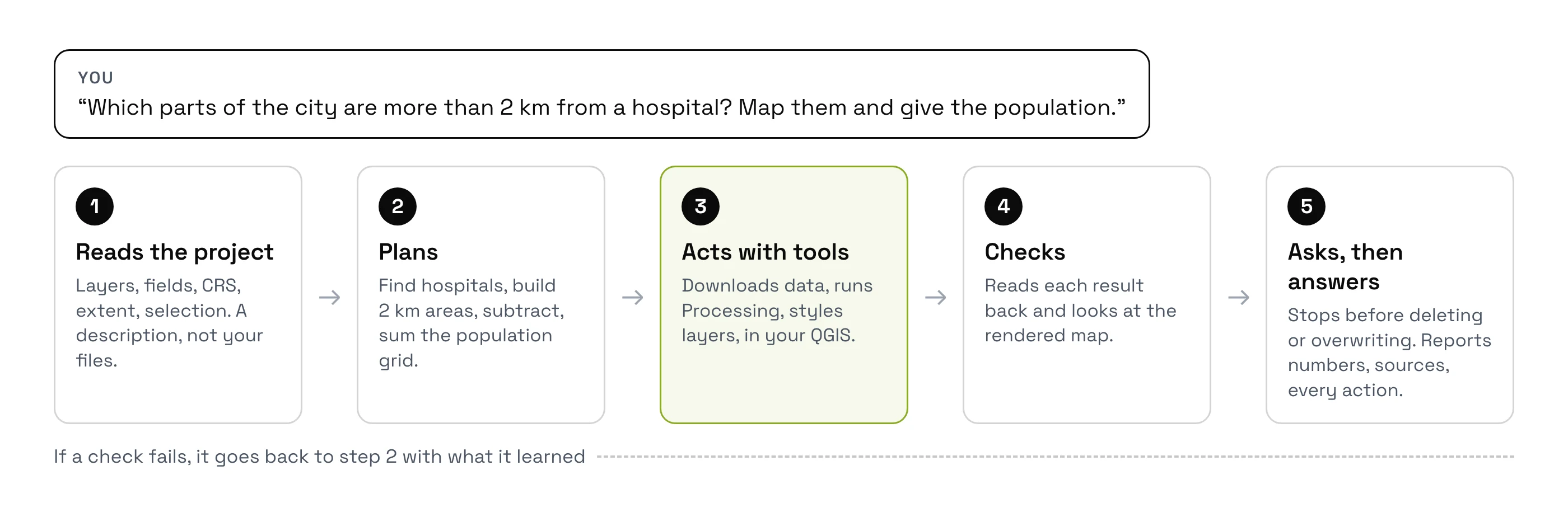
- It reads your project. Layer names, fields, coordinate system, map extent and selection. A good agent sends a description of the project to the AI, not your data files.
- It plans. A big task becomes a short list: find the data, clip it, compute, style, report.
- It acts through tools. Each step runs a real QGIS tool: a Processing algorithm, a layer style, a data download, a print layout. Some agents also write and run Python when no tool fits.
- It checks its work. It reads what each tool returned, and the better ones look at the rendered map before answering.
- It asks before risky changes. Deleting a layer or overwriting a file should need your click.
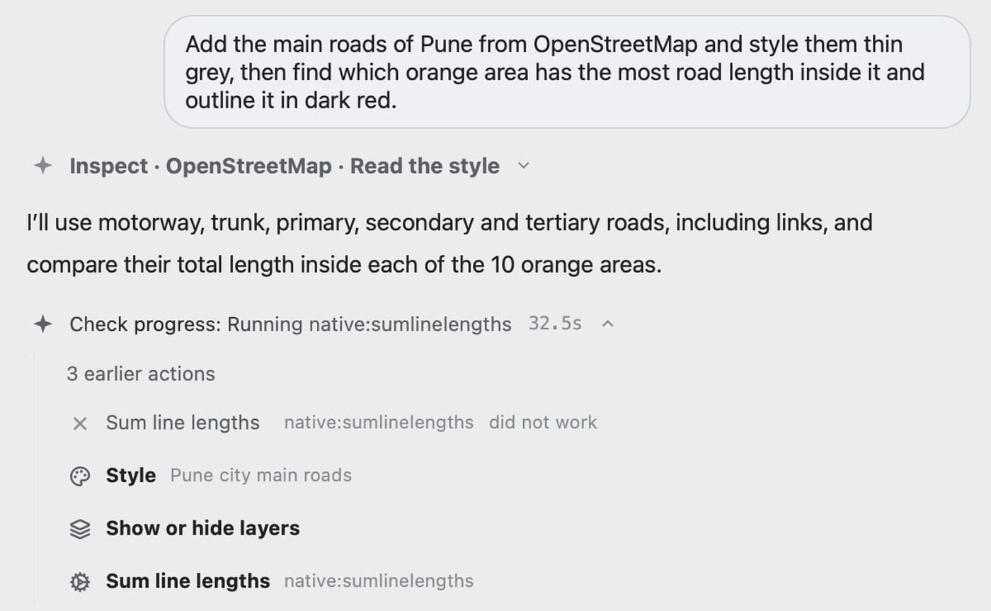
Here is the loop from the inside. Asked to add Pune's main roads and find the orange area with the most road length, the agent first says which roads it will use. Then it runs tools one by one, and when one fails, it reads the error and tries again.
One run, checked by hand
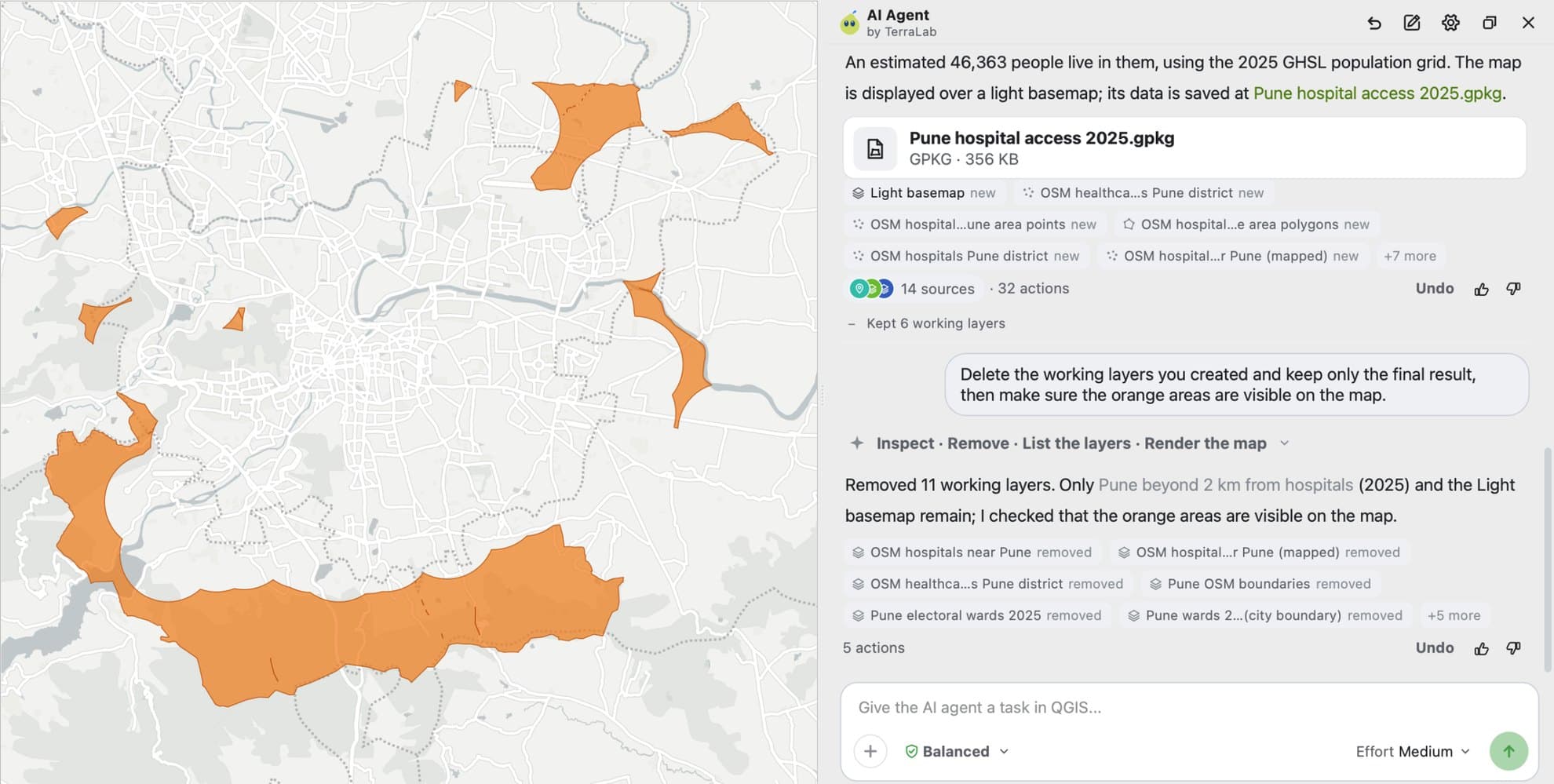
Can you trust an agent's numbers? I gave ours one question in an empty project: "Which parts of Pune, India, are more than 2 km from the nearest hospital? Use OpenStreetMap hospitals, map those areas in orange over a light basemap, and tell me how many people live in them." It found the city's districts on its own, 645 hospitals and a population map, and ran 32 actions. It worked for about 3.5 minutes. The rest of the 8 min 37 s was two approval cards waiting for me.
Then I redid the analysis by hand in the same session:
| Measure | Agent | My manual check | Gap |
|---|---|---|---|
| Area more than 2 km from a hospital | 107.29 km² | 107.54 km² | 0.23% |
| People living there | 46,363 | 46,372 | 0.02% |
The numbers held. The map didn't, at first: after its last check, the agent added a green layer on top that hid the orange areas, while its answer said they were visible. It fixed that when I asked. So an agent that checks its work saves you most of the effort, and you still look at the map.
How we measured this. QGIS 3.44.7, AI Agent 1.4.1, default settings, 26 September 2026. For the manual check, I drew 2 km circles around the same 645 hospitals, subtracted them from the city's 41 districts, and added up the population grid inside with QGIS zonal statistics.
The same question works in your own QGIS, on your own city: install the plugin, sign in, and paste it into the panel.
Try AI Agent free in QGIS, no card needed
What people use QGIS agents for
An agent suits tasks with many small steps you already know how to do, where the time goes into clicking and looking things up:
- Finding open data for a place, checking the licence and loading it styled.
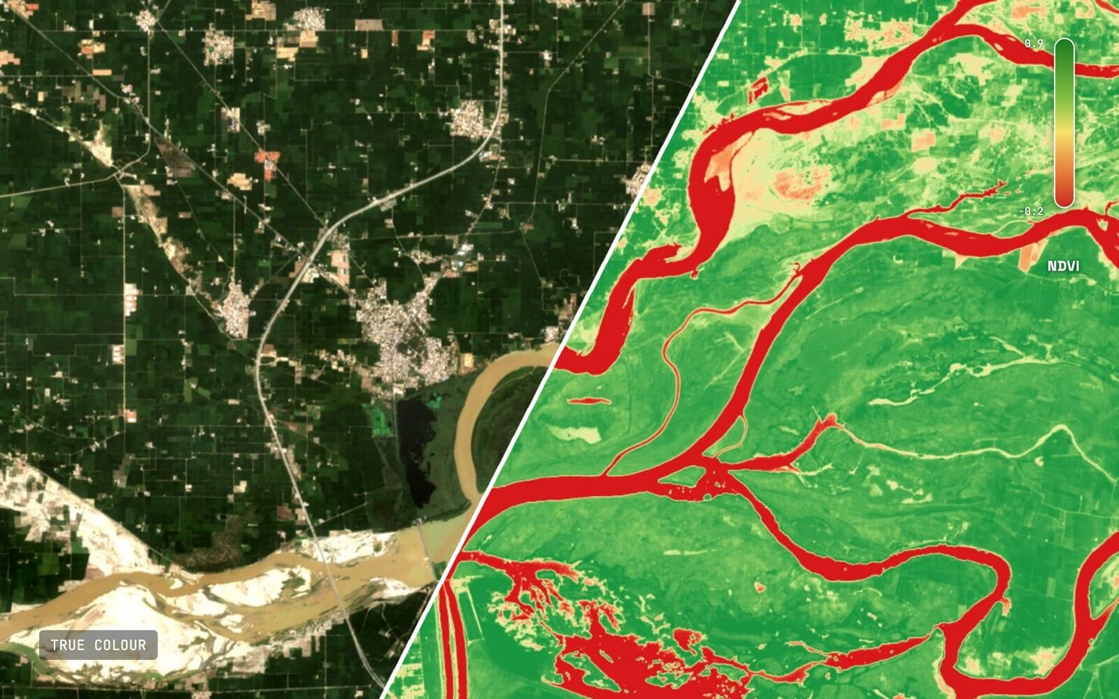
- Computing an index from satellite imagery, such as NDVI or a burn severity map.
- Running a chain of Processing tools, like buffer, clip, dissolve and count, and giving the numbers.
- Building a print layout with a legend, a scale bar and a north arrow, then exporting a PDF.
- Fixing the everyday problems: a layer in the wrong CRS, invalid geometry, a CSV that won't map.
Our AI Agent guide walks through ten real runs of that kind, each with its exact prompt and how long it took.
We counted every AI agent plugin for QGIS
Nobody had counted these plugins. On 26 September 2026 we went through the official QGIS plugin list and kept every plugin where an AI language model acts on QGIS or answers about your project. There are 38.
38
agent and assistant plugins
58%
first published in 2026
47%
need your own API key
21%
are MCP bridges to an outside app
Twenty-two of the 38 appeared in 2026. Twenty-three already work with QGIS 4, and nine are marked experimental by their own authors. An API key, in the table below, is a personal password you buy from an AI company such as OpenAI and paste into the plugin; MCP is a way for an outside AI app to drive QGIS.
The most downloaded:
| Plugin | Author | Downloads | How it gets a model | Where you chat |
|---|---|---|---|---|
| QChatGPT | KIOS Research Center | 97,949 | Your OpenAI key | Panel in QGIS |
| QGIS MCP | Nicolas Karasiak | 52,575 | Your own AI app | Outside QGIS, in an MCP client |
| AutonomousGIS Spatial Analysis Agent | Akinboyewa, Li, Ning, Lessani | 21,783 | Your API key | Panel in QGIS |
| Aino | aino.world | 21,032 | Not stated | Panel in QGIS |
| Kue | Bunting Labs | 15,892 | Vendor account | Panel in QGIS |
| OpenGeoAgent | Qiusheng Wu | 9,853 | Your key, or a local model | Panel in QGIS |
| Geo Knowledge AI | phoenix-gis | 9,794 | Vendor-hosted | Panel in QGIS |
Old plugins collect more downloads, so the ranking says more about age than quality. QChatGPT, at the top, hasn't been updated since July 2023. The AutonomousGIS agent comes from a research team that tested it on over 100 analysis tasks: reliable on basic and intermediate ones, less so on complex ones. OpenGeoAgent is by Qiusheng Wu, a friend of ours, whose free GeoAI plugin is the reference for image models in QGIS.
How we counted. We read the official plugin list for QGIS 3.44 and 4.0 on 26 September 2026, searched for words such as agent, LLM, MCP, chatbot and assistant, then read each plugin's page. We kept only those where a language model acts on or answers about QGIS.
Three ways an agent gets its model
Ask first where the AI model comes from. It decides the setup, the bill and where your requests go.
| Setup | How it works | Good | Watch for |
|---|---|---|---|
| Your own API key | Paste an OpenAI, Anthropic or Gemini key into the plugin | Pick any model, pay the provider directly | A separate bill per token, and a key to keep safe |
| A vendor account | Sign in, the vendor runs the model | Nothing to configure, one subscription | Your prompts go to that vendor |
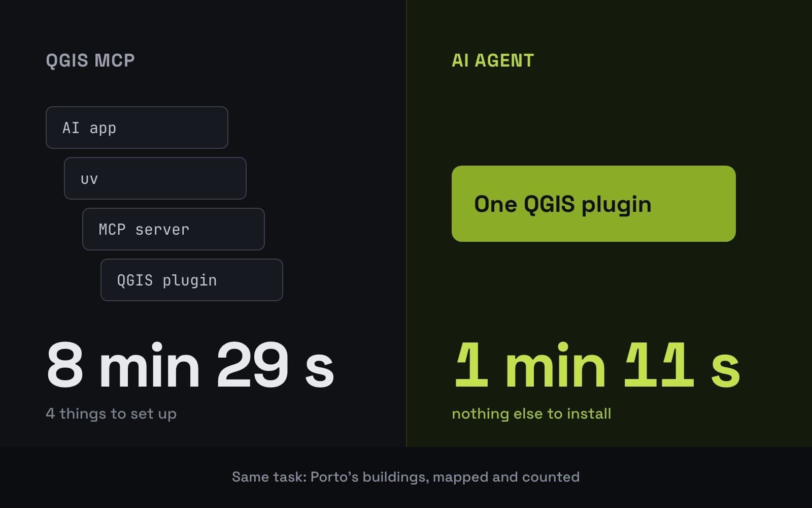
| An MCP bridge | The plugin opens a local socket, and an outside app such as Claude Desktop drives QGIS | Use the AI app you already pay for | Several parts to install and start, and the chat lives outside QGIS |
| A local model | The model runs on your machine through Ollama or similar | Nothing leaves the computer | Small local models plan multi-step GIS work poorly, and you need the hardware |
The MCP route gets the most searches and has the hardest setup, so it has its own page.
The risks, and how to check an agent
An agent that acts can also act wrongly. The main risk in QGIS is Python: many agents write and run code when no tool fits, and Python inside QGIS can change or delete any file on your computer.
Security teams take this seriously. NVIDIA's AI security team found a flaw of this kind, CVE-2024-12366, and concluded that running AI-written code in a closed-off space "is essential" (NVIDIA, 2025). One plugin in our count says in its own README that its Python tool "auto-runs (no per-step confirmation)".
Before I let any agent near a client project, I check five things:
- Does it ask before deleting or overwriting? Try "delete the layers you created" and see whether it stops.
- Can you undo a whole message? QGIS's own undo covers edits, not added layers or written files.
- Does it show every action it ran? You need to be able to audit what happened.
- What leaves your machine? A description of the project, or your actual data?
- What does a heavy day cost? Per-token billing on your own key has no ceiling unless you set one.
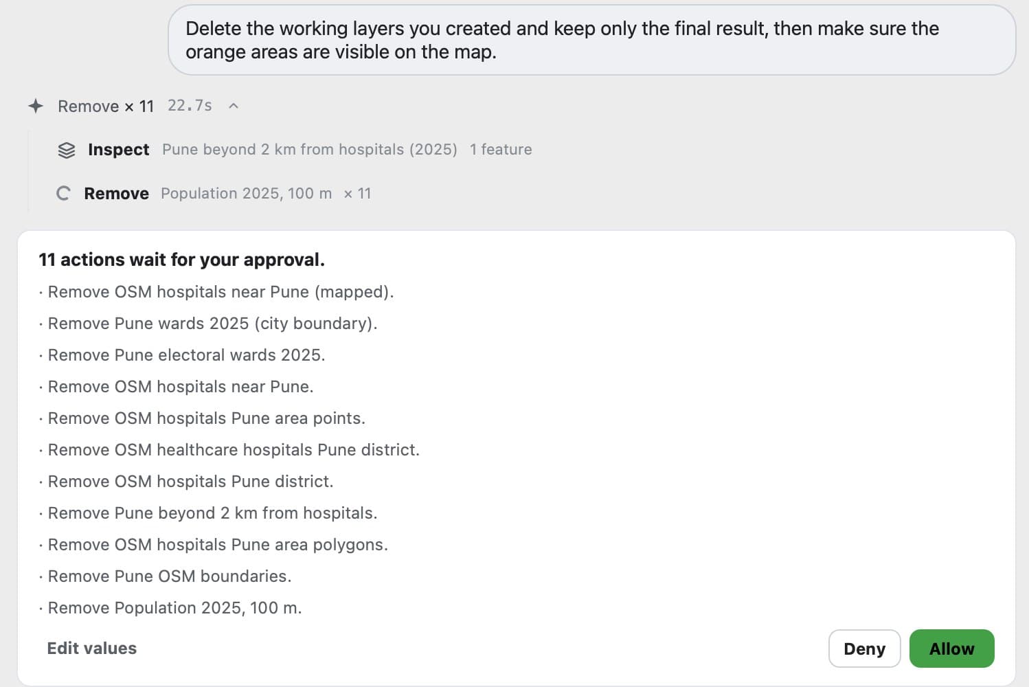
This is what the first check looks like when it passes. I asked our agent to delete the working layers it had created, and it stopped with the list of eleven removals before touching anything.
Does ArcGIS have an AI agent?
Esri, the company behind ArcGIS, offers about ten small AI assistants, most in beta, each for one product such as StoryMaps or Survey123. The ArcGIS Pro assistant was invitation-only in January 2026 and opened as a beta to paying ArcGIS Online users by May. QGIS went the other way: dozens of community plugins, most free, several of them agents that run whole tasks. The QGIS vs ArcGIS comparison covers the rest.
Which AI agent should you use?
It depends on where you want to chat, who pays for the AI, and whether your data can leave your computer. Here is how I'd choose:
| If you want | Look at | Why |
|---|---|---|
| The result in your project, with no setup | AI Agent (ours) | One plugin, model included, asks before risky steps, one-click undo per message |
| QGIS as one more tool in Claude Code or Cursor | QGIS MCP | Free, uses the AI plan you already pay for, more setup |
| Nothing leaving your computer | OpenGeoAgent with a local model | Runs through Ollama; plan for a strong GPU, since small models struggle with multi-step work |
| Your own OpenAI or Anthropic key | AutonomousGIS or OpenGeoAgent | Pay the provider per token, pick any model |
| Research-grade evaluation | AutonomousGIS | Tested on 100+ tasks in a published paper |
Most GIS users I talk to want the first row: type the task, get the layer. Developers who already live in a code editor often prefer the second.
How to try an AI agent in QGIS
Every plugin in the census installs the same way: Plugins > Manage and Install Plugins, search for its name, Install Plugin.
The agent we build
We build AI Agent, so this part is about our own plugin. It's a chat panel inside QGIS with the AI included: you sign in once, with no API key and no extra app. It asks before deleting or overwriting, lists every action under each answer, and saves a version of your project at every message.
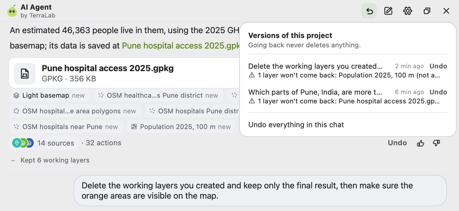
Going back restores the project's layers and styles, and it tells you what it can't restore, such as a file already saved to disk.
It sends a description of your project (layer names, fields, coordinate system, extent), never your data files, to a service hosted in the EU. There's a free plan with no card needed, and one message counts as one task however many steps it takes.
Try AI Agent free in QGIS, no card needed
What to remember
An AI agent in QGIS takes a task in plain language and runs it in your project: it reads the project, plans, runs QGIS tools, checks the result and asks before risky changes.
A chatbot answers and a copilot suggests. Only an agent does the clicking, so its safety settings matter as much as its AI model.
On 26 September 2026 the official QGIS repository held 38 agent and assistant plugins. 58% were first published in 2026, 47% need your own API key and 21% are MCP bridges to an outside AI app.
Before trusting one, check that it asks before deleting, that a whole message can be undone, that it shows every action, and what data leaves your machine.
Ours, AI Agent, answered a Pune hospital-access question within 0.23% of a manual check, asked before deleting layers, and keeps a version of the project per message.
Questions people ask
Is there an AI agent for QGIS?
Yes, several. On 26 September 2026 the official plugin list held 38 plugins where an AI model acts on QGIS or answers about your project. Some need your own OpenAI or Anthropic key, some a vendor account, and some let an outside app such as Claude Desktop drive QGIS. Ours, AI Agent, includes the AI and has a free plan.
What is the difference between an AI agent and a chatbot?
A chatbot answers in text and you do the work. An agent carries out the task: it plans the steps, runs tools in your software, checks what happened and reports back. In QGIS, a chatbot tells you how to compute NDVI, and an agent adds the NDVI layer to your map.
Can ChatGPT control QGIS?
Not by itself. ChatGPT can write PyQGIS code for you to paste into the QGIS Python console, but it can't act on your project. It can't connect to QGIS MCP running on your computer either: OpenAI's help centre says ChatGPT only reaches MCP servers on the internet. An agent plugin inside QGIS can act on the project directly.
Do I need an API key to use an AI agent in QGIS?
It depends on the plugin. Nearly half of the 38 we counted need your own key from OpenAI, Anthropic, Google or OpenRouter, billed per use by that provider. Others use a vendor account with the model included, and a few run a local model on your machine.
Is it safe to let an AI agent run Python in QGIS?
Python in QGIS can read, change or delete any file on your computer, so an agent that runs code without asking is a real risk. Use one that asks before running code that changes your project, shows every action it took, and can undo a whole message. Keep a backup of anything irreplaceable.
Does an AI agent work with QGIS 4?
Many do: 23 of the 38 agent plugins we counted were listed as compatible with QGIS 4 on 26 September 2026. Check the plugin's page in the repository, where the maximum supported QGIS version is shown.
To try an agent now, AI Agent installs from the QGIS plugin manager with a free plan. If the MCP route interests you, what QGIS MCP is goes through its setup and limits. The AI Agent guide has ten real runs with their prompts, what GeoAI is covers the image models that detect objects, and the best AI plugins for QGIS and the QGIS AI hub compare the wider field.