What Is GeoAI? Definition, Examples, Uses in QGIS
Published Updated
GeoAI is machine learning run on geographic data: satellite and aerial imagery, point clouds, vector layers, read by a model that hands back objects, classes or changes as data you can edit. What comes back arrives in your project CRS, as a layer you open in QGIS like any other. It handles the slow middle of a job, and it decides nothing for you.
 like any other. It handles the slow middle of a job, and it decides nothing for you.
It is not a chatbot that knows your project. It doesn't read your client's specification, your attribute rules, or the survey you did last spring, and nothing in it replaces ground truth. The word is loose as well: a random forest classifier from 2005 and a segmentation model from last year both get sold as GeoAI, so when a vendor uses the term, ask which one they mean, because the hardware bill and the failure modes are different.
We build one of the QGIS plugins in this space, so read this knowing whose article it is.
Why it matters
The slow part of most GIS jobs is the tracing. Squaring building corners, closing holes in a roof mask, outlining three hundred tree crowns one vertex at a time. That work has no craft left in it after the first hour, and a model is good at it.
It is not for every job. Under fifty features, digitize by hand, because you'll be finished with snapping turned on before a model has finished downloading its weights, and the result matches your spec exactly. I'd also keep it away from anything legal, a cadastral boundary, a protected zone, a compensation claim, since a model gives you a candidate and a candidate is not a survey. The line I hold is that GeoAI belongs in the first pass and never in the last one.
How it works
You hand a trained model a picture and it hands back geometry. Three families do that work, and they behave differently.
Segmentation models such as the Segment Anything family learn where one thing stops and the next begins. They were trained on ordinary photographs, so they carry no idea of what a building is for. They transfer to imagery well wherever the boundary is crisp. The SAM guide covers which QGIS plugins run which version.
Image-to-image models invent new pixels. That is how cloud removal, season change and cleared-site views work. The output is a georeferenced raster on the same extent, and it's a drawing, so it never belongs in an evidence layer.
Classical machine learning means a random forest or a support vector machine reading band values, one pixel at a time. Twenty years old, cheap, and still the right pick for multispectral land cover with your own training polygons. SCP and dzetsaka do it inside QGIS for free.
What people use it for
Five jobs, today, in the order I'd trust them.
| Task | Model family | Runs on |
|---|---|---|
| Pulling objects out of imagery | Segmentation, the Segment Anything family | A local graphics card, or a server |
| Classifying land cover | Classical machine learning | Any laptop |
| Spotting change between two dates | Segmentation, fed a pair of images | A server, or a graphics card |
| Filling and tidying data | No model. Plain geometry algorithms | Any laptop |
| Asking in plain words | Segmentation, prompted with the object name | A server, in our plugin |
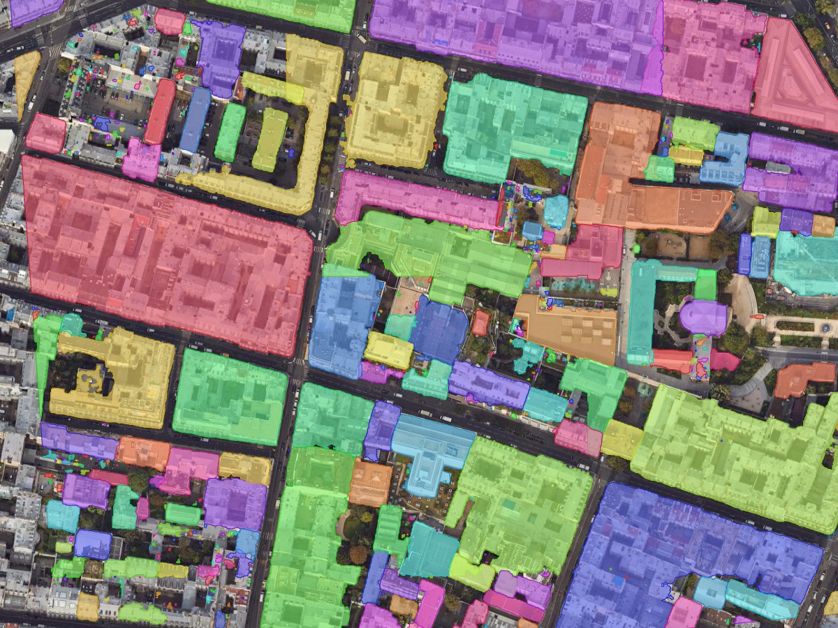
Pulling objects out of imagery is the strongest one by a distance. You outline an area, name what you want, and get polygons back: buildings, tree crowns, cars, pools, solar arrays. Sharp edges give clean outlines. A field boundary that fades into scrub gives the model the same trouble it gives you.
Classifying land cover puts every pixel in a class: water, built, bare soil, forest. Older methods still win here when you have good training polygons and multispectral bands, and they run on any laptop.
Spotting change between two dates means handing the model two orthophotos of the same place so it flags what moved. Where the vendor names its model it is a segmentation model with two inputs instead of one: Picterra names ChangeStar, and Esri's change detector cites STANet. Several vendors sell change detection and never say what is inside. The free route uses no model at all and subtracts one image from the other. It works on obvious change like a new building or a cleared plot. Seasonal colour shift and a different sun angle produce false alarms, so plan to review every flag.
Filling and tidying data covers squaring building corners, closing holes in a roof mask, simplifying an outline traced pixel by pixel. This is the one row where none of the three families applies. The tools that ship are geometry algorithms older than deep learning: QGIS does it with Simplify and Orthogonalize, Esri with Regularize Building Footprint. Learned versions exist in research and none of them ships in QGIS today. Unglamorous, and the part that saves the most hours.
Asking in plain words means typing solar panels instead of picking a model and a band combination. Useful for finding things. Don't expect it to answer questions about your attribute table.
What it costs to run
Hardware. A local model needs a graphics card. Segment Anything 3 has no CPU path at all, which rules out every Mac and every machine on integrated graphics. When the model runs on a server instead, an office laptop is enough, and that is the trade we made.
Imagery. Ground resolution decides more than the model does. Our own tuning aims for roughly 0.05 m per pixel on a solar panel, 0.09 on a car, and 0.18 on a building. Coarser than that and the object is a smudge no model recovers.
Time. Detection takes minutes. The review takes longer, and anyone who leaves it out of the estimate is going to miss the deadline.
Money. The free QGIS options cost nothing but your GPU and an afternoon of Python. Ours gives 1.5 km² of automatic detection a month with no card, plus click-to-segment on your own machine with no counter, and Pro runs €39 a month for AI Segmentation, excluding VAT. On the Esri side, the ready-made image models need an ArcGIS Pro Professional licence or higher, and QGIS vs ArcGIS Pro puts a price on each licence.
Try it free in QGIS, no card needed
How to do it yourself in QGIS
Start with the free path, because for a good part of this work it is also the better one. For multispectral land cover with your own training polygons, SCP and dzetsaka classify inside QGIS at no cost and on any laptop.
Segmentation on your own machine is the harder half. The free plugins want a graphics card and an afternoon of Python, and the SAM guide says which one runs which version of the model. The footprints guide walks the free path and the paid one over the same neighbourhood, so you can weigh what each one costs you.
The cloud option
We build the plugin below, so this section is about our own tool.
Open the plugin manager
Plugins -> Manage and Install Plugins. QGIS 3.22 or later.
Install AI Segmentation
Nothing else downloads, and there is no Python environment to build.
Sign in from the panel
An email and a click. The free allowance renews monthly and asks for no card.
Draw a zone on imagery you already have open
Any visible raster works: a GeoTIFF, a drone orthophoto, an XYZ basemap. Free accounts cover 1.5 km² of ground a month.
Type the object, then review
building, tree, car. Filter by confidence and size, fix what is wrong, export a GeoPackage.
Then compare what comes out against what you would have digitized by hand. That is the only test that settles it.
What to remember
GeoAI is machine learning run on geographic data, and what it hands back is a layer in your project CRS, never an answer about your project.
Under about fifty features, digitize by hand. You finish before a model has downloaded its weights, and the result matches your specification.
A model returns a candidate, and a candidate is not a survey, so a cadastral boundary, a protected zone or a compensation claim needs the hand-checked layer.
Segment Anything 3 has no CPU path at all, which rules out every Mac and every machine on integrated graphics for a local run.
Ground resolution decides more than the model does, and there is no single accuracy figure, because accuracy moves with your imagery and with what you extract.
Four myths worth clearing up
A single accuracy number. Accuracy moves with your imagery and with what you extract. Anyone quoting one figure across all of it is quoting a marketing number.
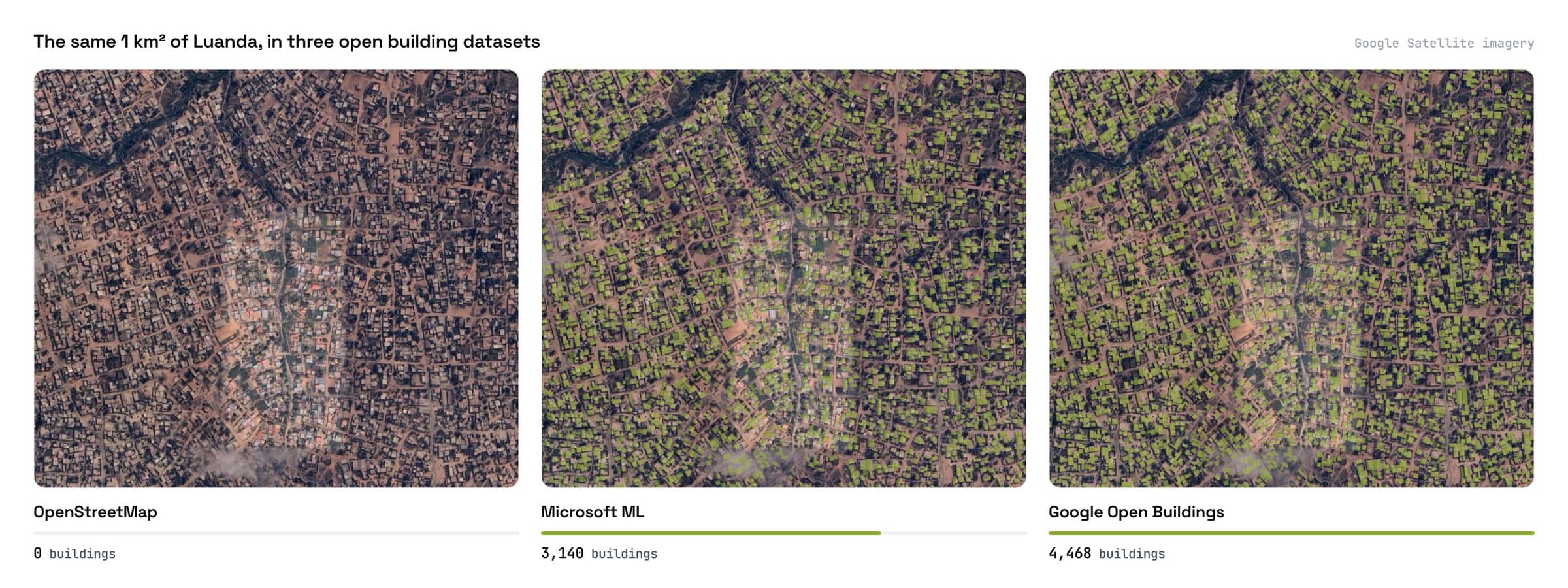
Training data that never saw your region. Ready-made building layers are the clearest case. The same square kilometre of Luanda holds nothing in OpenStreetMap, 3,140 footprints from Microsoft, and 4,468 from Google Open Buildings.
"Runs locally, your data never leaves your computer." True of a small model on your machine. Every cloud mode sends imagery somewhere, ours included, and the honest thing is to say which mode you are in.
Output you can ship straight away. Every run returns more than you asked for: vents, skylights, shadows, courtyard sheds. Real objects with correct outlines, and not the thing you wanted. Budget for the cleanup.
Questions people ask
Is GeoAI the same thing as remote sensing?
No. Remote sensing is the measurement. GeoAI is one way of reading that measurement, alongside indices, thresholds and your own eyes.
Do I need to write code?
For the classical path, some. For segmentation in QGIS, no, because the plugins cover it. Python still wins when you run the same pipeline over hundreds of tiles, and PyQGIS is how you drive QGIS from it.
Do I need a GPU?
Only for models that run on your own machine. Segment Anything 3 has no CPU path at all, so a Mac or a laptop on integrated graphics cannot run it locally. Server-side tools need none.
How accurate is GeoAI?
There is no one number, because accuracy moves with your imagery and with what you extract. Expect every run to return more than you asked for, vents and skylights and courtyard sheds among the buildings, and budget for the cleanup.
What comes out at the end?
Polygons with a label, a class, a confidence score and an area, in your project CRS. Our segmentation plugin writes them to a styled GeoPackage. You still own the review.
For the neighbouring terms, what a building footprint is covers the object GeoAI extracts more often than any other, and the QGIS AI hub lists what each plugin in this space needs before it will run.