Satellite Imagery Resolution Compared: What You See at 30 m, 10 m, 3 m and 30 cm
Published
Satellite imagery resolution is the size of one pixel on the ground. Free satellites stop at 10 m (Sentinel-2) and 30 m (Landsat), commercial ones reach 3 m, 1.5 m, 50 cm and 30 cm, and aerial photos and drones go down to 20 cm and a few centimetres. In one French suburb, 0.2% of buildings cover 16 pixels or more at 10 m. At 50 cm, 96% do.
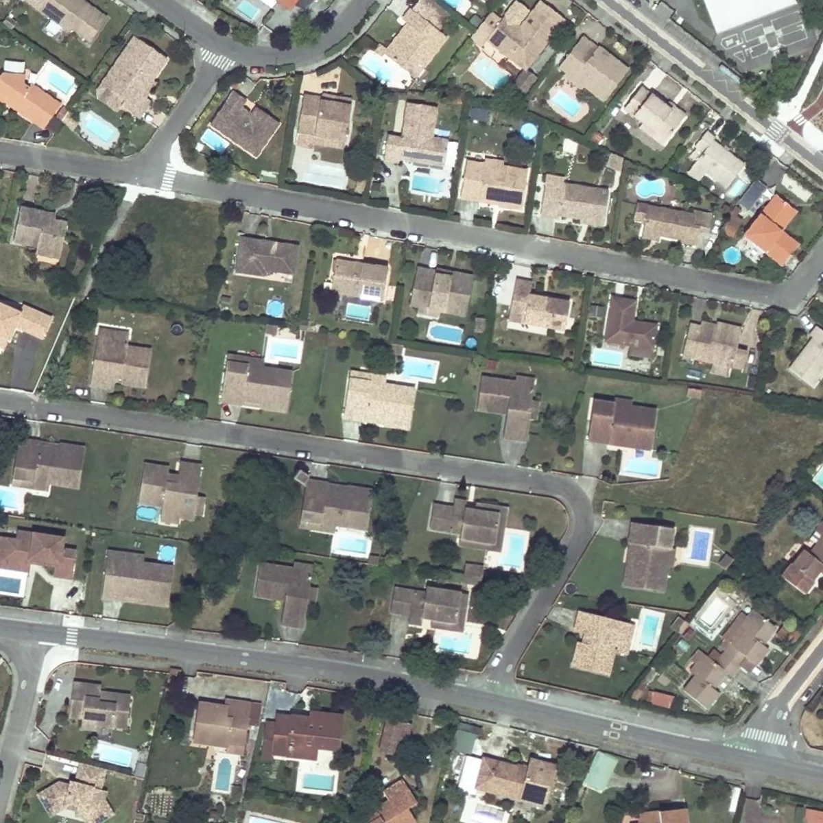
On the left you can count the pools. On the right, each Sentinel-2 pixel covers 100 m², about three garden pools, and blends roof, lawn, water and street into one colour.
What resolution means in a satellite image
Resolution, or ground sample distance (GSD), is the distance between two pixel centres measured on the ground. A 10 m image gives one colour value per 10 × 10 m square, whatever stands in it. Anything much smaller than a pixel melts into its neighbours, so the useful question is how many pixels your object covers.
Satellite imagery resolution compared, sensor by sensor
Free satellites stop at 10 m, commercial satellites reach about 30 cm, and only aircraft and drones go finer. I checked each pixel size on the operator's page on 5 October 2026: USGS for Landsat, ESA for Sentinel-2, CNES for Pléiades and IGN for the French orthophoto. The last column is my own count, explained below.
| Source | Pixel size | Cost | Revisit | Tournefeuille buildings covering 16+ pixels |
|---|---|---|---|---|
| Landsat 8 and 9 (USGS) | 30 m colour, 15 m panchromatic | Free | 8 days, two satellites | 0.01% |
| Sentinel-2 (ESA) | 10 m | Free | 5 days | 0.2% |
| PlanetScope (Planet) | 3 m (3.7 m native) | Paid | Near daily | 23% |
| SPOT 6 (Airbus) | 1.5 m | Paid | On request (SPOT 7 ended in 2023) | 50% |
| Pléiades (Airbus) | 50 cm (70 cm native) | Paid | Daily | 96% |
| Pléiades Neo (Airbus), WorldView Legion (Vantor, formerly Maxar) | 30 cm class | Paid | Daily to several a day | 99.9% |
| IGN BD ORTHO, France (aerial) | 20 cm | Free | Every 3 to 4 years | 100% |
| Drone | 2 to 5 cm | Your own flight | When you fly | 100% |
Vantor is the name Maxar Intelligence took in October 2025. The jump that matters sits between 3 m and 50 cm, where houses go from blobs to shapes.
The same block at six pixel sizes
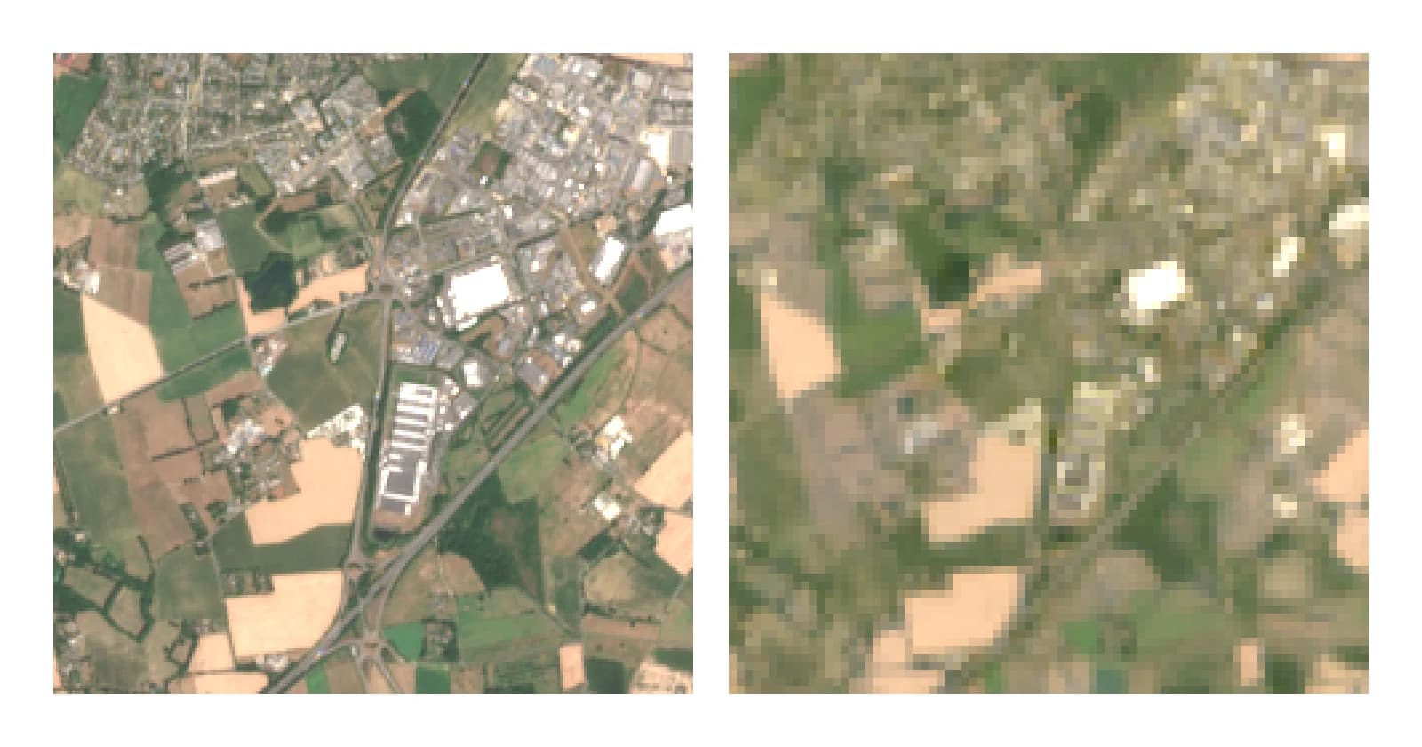
Between 3 m and 50 cm, a suburban street goes from blocks of colour to houses and pools you can count. I took one block of Tournefeuille, a suburb west of Toulouse, from the IGN 20 cm orthophoto flown on 16 and 17 June 2025, and averaged its pixels into 50 cm, 1.5 m, 3 m, 10 m and 30 m cells. Next to the simulated 10 m and 30 m tiles are the real Sentinel-2 and Landsat 8 images from 18 June 2025.
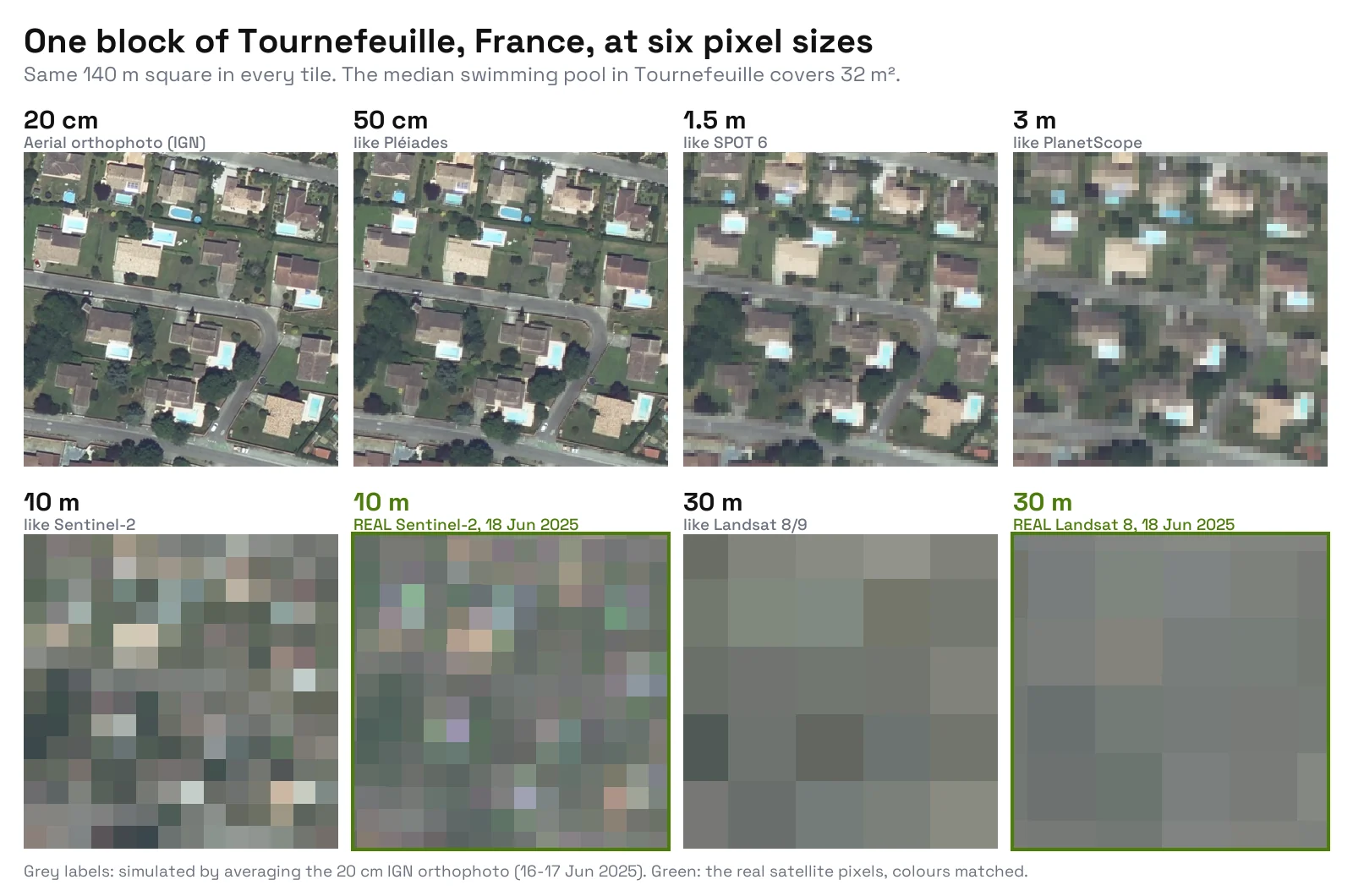
The simulation flatters the satellites a little: the real Sentinel-2 tile is just as blocky, with extra colour noise from the sensor and the atmosphere. Neither 10 m tile shows a single pool, and at 30 m the block is about 25 grey squares.
How many buildings and pools each resolution can see, measured
At 10 m, 0.2% of the 20,911 buildings in Tournefeuille cover 16 pixels or more, against 23% at 3 m and 96% at 50 cm. For its 2,966 mapped swimming pools the cliff is steeper: 37% at 1.5 m, one single pool at 3 m, none at 10 m.
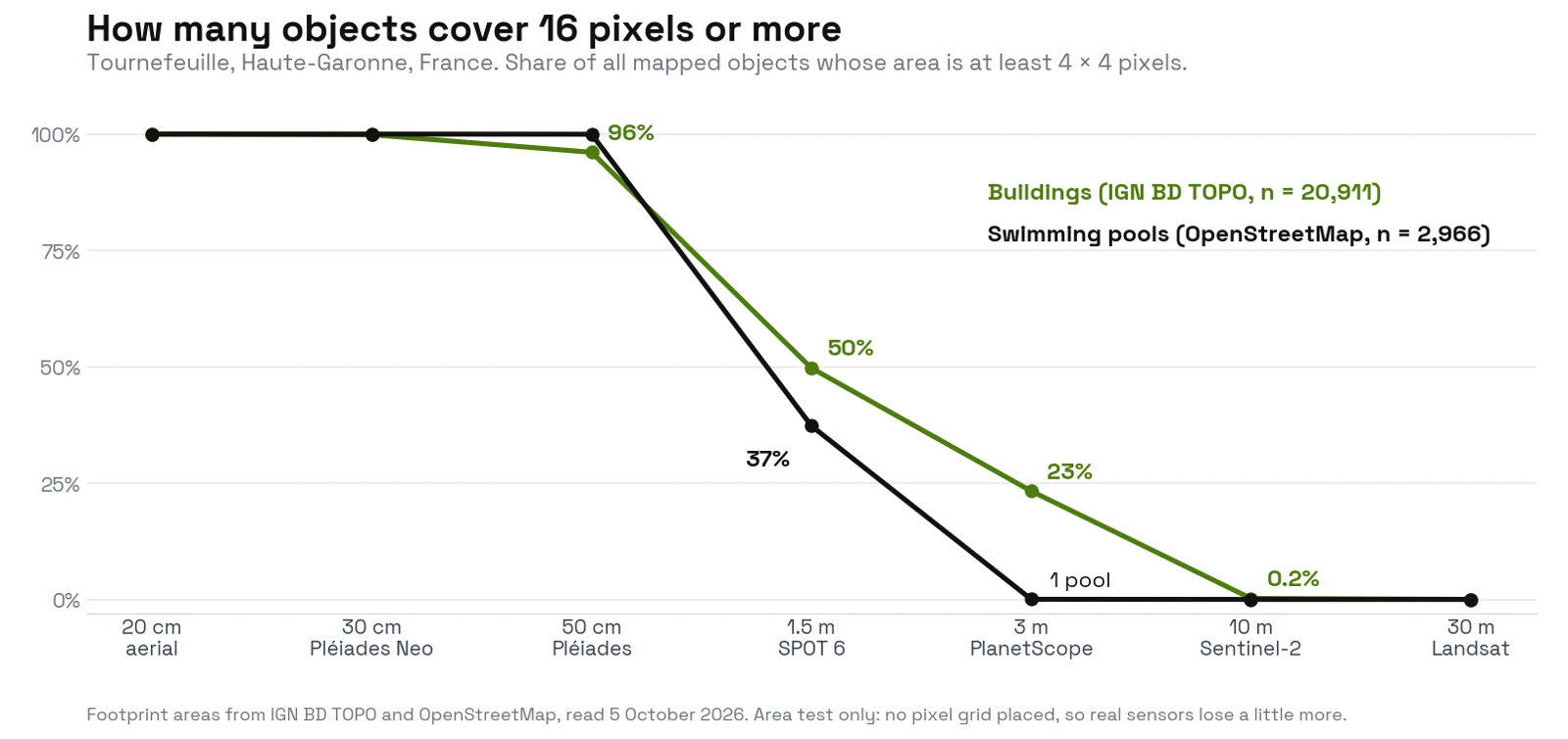
With a looser 2 × 2 threshold (something is there, shape unknown), 1.9% of buildings pass at 10 m and 37% of pools at 3 m. The median pool covers 32 m², a third of one Sentinel-2 pixel. A second commune, Sommières in the Gard, gives the same picture: 0.3% of its 3,345 buildings at 10 m, 99% at 50 cm.
How I measured this. On 5 October 2026 I took every IGN BD TOPO building and every OpenStreetMap swimming pool inside the commune boundary and computed each one's area. An object counts as visible when its area is at least 16 pixels (4 × 4). That threshold is a working rule of thumb for an object to keep a recognisable shape, not a standard. Limits: OpenStreetMap pools are a volunteer count, not a census, and an area test places no pixel grid, so a real sensor loses a few more objects. If a 4 × 4 pixel square has to fit inside the footprint, buildings at 3 m drop from 23% to 3%. BD TOPO also counts garages and sheds, so half the buildings are under 35 m².
Which resolution for which job in QGIS
Use 10 to 30 m for land cover, 3 to 10 m for fields, and 50 cm or finer for anything you count one by one.
- Land cover, forest, water, urban extent. Sentinel-2 or Landsat, free and frequent.
- Crops and field boundaries. Sentinel-2 at 10 m for fields above about a hectare, PlanetScope at 3 m for small plots or daily follow-up.
- Buildings. 50 cm or finer. Half the buildings of Tournefeuille still read as shapes at 1.5 m, but the small ones don't.
- Pools and cars. 50 cm or finer. A car covers about 8 m², so 16 pixels needs a 70 cm pixel at most.
- Roof details, solar panels, cracks. 20 cm aerial photos or a drone, see orthomosaic vs orthophoto.
My opinion: in France, don't pay for 30 cm satellite imagery to map buildings or pools. The free IGN 20 cm orthophoto is sharper, and the paid image only wins when you need a more recent date. We build AI Segmentation, the QGIS plugin that returns one polygon per building, tree or pool. It reads RGB only, so the same rule applies: give it 50 cm or finer, such as the IGN orthophoto through WMS. The building footprint and swimming pool guides run it on real orthophotos.
Questions people ask
What is the highest resolution satellite imagery available to the public?
About 30 cm native, from WorldView-3, WorldView Legion and Pléiades Neo. Albedo holds a US licence for 10 cm, but as of October 2026 I found no 10 cm satellite imagery on sale.
Is 30 cm the legal limit for commercial satellite imagery in the US?
No. The US raised the limit from 50 cm to 25 cm in 2014, and NOAA's 2020 rule replaced fixed limits with three licence tiers based on whether the same data is sold elsewhere. Today's ceiling of about 30 cm comes from the satellites, though a licence can still carry conditions.
Where can I get free high-resolution imagery?
Sentinel-2 at 10 m is the best free satellite source worldwide. Finer free imagery is aerial and national, such as the IGN BD ORTHO at 20 cm in France.
What does GSD mean?
Ground sample distance: the ground distance between two pixel centres. A 50 cm GSD means one pixel covers 50 × 50 cm. It grows when the sensor looks sideways or flies higher.
Can AI sharpen a 10 m Sentinel-2 image?
Partly. Super-resolution models such as SEN2SR output 2.5 m images, but they guess detail the sensor never recorded. A 32 m² pool is a third of one pixel, and no model can recover its outline from that.
To stream the free 10 m imagery, see how to download Sentinel-2 in QGIS. The QGIS AI hub lists the AI tools that extract objects from imagery at each scale.