Plot Plan vs Site Plan: The 8 Items 19 Permit Offices Check
Published Updated
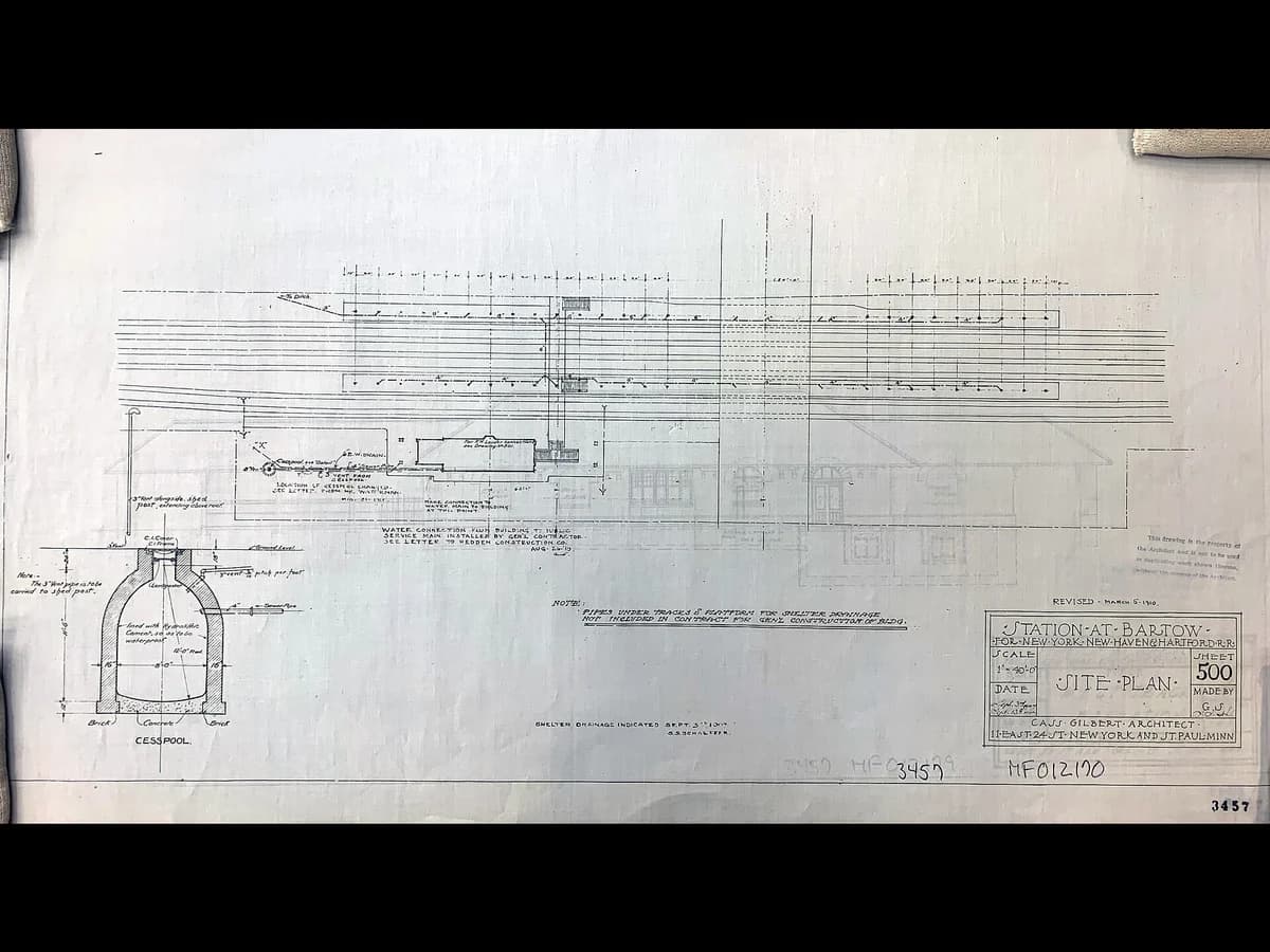
A plot plan is a scale drawing, seen from above, of one parcel of land: its property lines, the buildings on it, and the measured distance from each building to each line, the setbacks. A site plan is a drawing of a whole project: buildings, roads, parking, drainage, landscaping and utilities, over one parcel or several.
For a house, the plot plan is the sheet a building department checks before it permits a new home, an addition, a garage, a shed, a deck or a pool.
That is the textbook split. We read the submission checklists of 19 US permit offices to see whether they follow it, and the name on the form turned out to say little about what goes on the drawing.
Plot plan checklist before you file:
- Property lines, with the length of each side
- Every building on the lot, existing and proposed, with its outside dimensions
- The distance from each building to each lot line (18 of the 19 checklists ask for it)
- The street, the driveway and any easement crossing the lot
- Grades or drainage arrows, if your office asks for them
- A stated scale, a north arrow and a title block with the address and the date
- A surveyor's or engineer's seal, if the form says certified, stamped or sealed
The difference in one line
A plot plan answers "where does the house sit on the lot". A site plan answers "how does the project work on the site".
| Plot plan | Site plan | |
|---|---|---|
| Covers | One lot | The project, one or many lots |
| Drawn by | A surveyor, or the builder from the survey | An architect or a civil engineer |
| Usually asked for by | A building, fence or pool permit, a mortgage lender | A planning approval, a subdivision |
| Other names | Plat of survey, mortgage survey | Layout plan, in Britain a block plan, in France a plan de masse |
Those are the usual meanings. Permit offices bend both, as the next section counts.
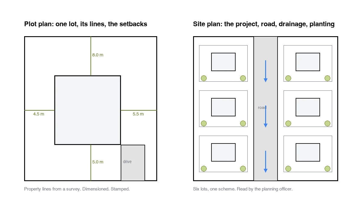
What does a plot plan look like?
A plot plan looks like a small map of one lot seen from straight above. The property lines form a closed outline with the length of each side written on it. The house is a shaded shape inside, dimension lines run from each wall to the nearest lot line, and the street runs along one side. A north arrow, a scale and a title block complete the sheet.
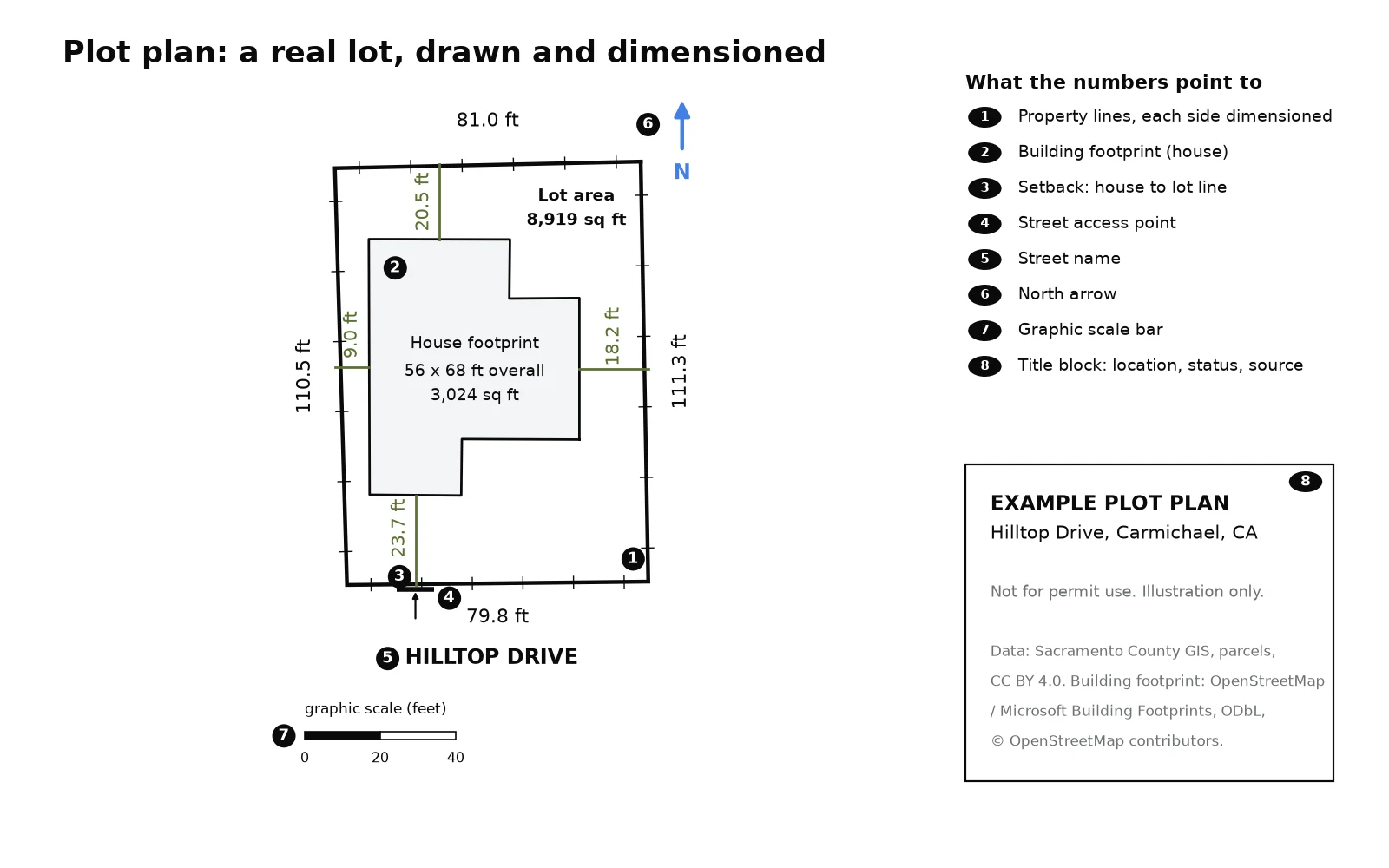
What a plot plan contains
The counts in brackets come from the 8 permit checklists in the next section that call the drawing a plot plan.
- Property lines, with the length of each side and the lot area (8 of 8). A survey-based plan also gives each line's bearing.
- Every building, existing and proposed, with its outside dimensions: the house, a garage, a shed, a deck, a pool.
- Setbacks: the measured distance from each building to each lot line, and between buildings (7 of 8).
- The street and the access: the street name, the driveway and where it meets the road.
- Easements and rights of way that cross the lot (5 of 8).
- Grades or drainage: spot heights, contours or arrows showing where water runs (5 of 8).
- Wells, septic systems and utility lines, mostly where there is no public sewer (3 of 8).
- A stated scale (7 of 8) and a north arrow.
- A title block: the address, the parcel number, the owner, who drew it and the date.
What 19 permit offices ask to see on a plot plan
In the 19 US residential permit checklists we read on 23 September 2026, the drawing called a plot plan asked for grades or drainage about as often as the one called a site plan: 5 of 8 plot plan checklists did, against 4 of 6 site plan checklists. Most of the guides that rank for this question say a plot plan rarely shows grading, drainage or utilities. The offices we read do not work that way.
18/19
checklists want building-to-lot-line distances
5/8
plot plan checklists ask for grades or drainage
4/8
plot plan checklists need a surveyor's or engineer's stamp
Each cell below is the number of checklists in that group that ask for the item in words. The groups follow the name the office gives the drawing.
| Item on the drawing | Called plot plan (8) | Called site plan (6) | Both names, one drawing (5) |
|---|---|---|---|
| Distances from buildings to lot lines | 7 | 6 | 5 |
| Lot lines | 8 | 3 | 4 |
| A stated scale | 7 | 4 | 4 |
| Easements | 5 | 4 | 4 |
| Grades, contours or drainage | 5 | 4 | 2 |
| Wells, septic or utility lines | 3 | 3 | 2 |
| North arrow | 2 | 3 | 3 |
| Licensed surveyor or engineer | 4 | 1 | 0 |
The setback is the one constant. Only Shasta County, California, leaves it out in so many words. If your drawing proves nothing else, it has to prove the building clears the lot lines.
Where the name does change something is who signs it. Four of the 8 plot plan checklists require a licensed land surveyor or engineer: all three Massachusetts towns in the sample, and Superior, Colorado, for a new house. Belmont wants "the seal of a Massachusetts Registered Land Surveyor", dated within six months of filing. Of the other 11, only Chapel Hill, North Carolina, asks for a survey, and only for new dwellings. King County, Washington, accepts hand-drawn site plans for small and simple projects.
Five offices use both names for one drawing. Plano, Texas, titles its handout "Residential Plot/Site Plan Submittal Requirements". Washington County, Oregon, asks for a "site/plot plan" with every building permit. Winnsboro, Texas, writes "Site plans (plot plans)". Utah County's handout is headed "Plot plan example", in a file named site-plan-example.
In Southern California, a plot plan can be a warehouse. Los Angeles City Planning calls the drawing filed with a planning application a plot plan (form CP-7752, December 2024), with tables for parking spaces, open space, landscaping and housing units. Riverside County uses Plot Plan as the name of the application itself: Plot Plan No. 220002 proposes a 434,823 sq ft industrial building on 20.57 acres. That turns the "plot plan for small jobs, site plan for big ones" rule upside down.
What we take from it: open your own office's checklist and draw what it lists, whatever it calls the drawing.
How we measured this
The sample is 19 residential building-permit checklists (new house or addition) published by US towns, cities and counties, found through web searches on 23 September 2026 for "plot plan requirements" and "residential site plan requirements", and kept when the document lists what the drawing must show. An item counts only when the document asks for it in words, "as applicable" included.
The 19, by state. Massachusetts: Belmont, Lexington, Northborough. Colorado: Superior, Lakewood. California: Shasta County, San Fernando, San Marcos, Los Angeles County, Burbank. Utah: Utah County. North Carolina: Charlotte, Chapel Hill. Washington: King County, Klickitat County. Maryland: Annapolis. Oregon: Washington County. Texas: Plano, Winnsboro.
Limits: it is a search sample, not a random one, of 19 offices out of thousands, weighted toward California (5 of the 19) and Massachusetts (3). The documents date from 2000 (Los Angeles County) to 2026. A checklist says what an office asks for at intake, not what a reviewer adds later, and one that skips an item may still expect it.
What each one is for
The plot plan proves one thing: the building stands where zoning says it may, with the measured distance from every wall to every property line. Because it certifies distances, it is drawn from a survey. In the US it comes up at three moments: the building permit for a new house, an addition, a fence or a pool; the survey a lender orders before closing; and a zoning variance request when a project does not meet the standard setback.
The site plan shows how a project fits its site and its neighbours. A planning officer reads it for parking counts, fire access, where the stormwater goes. It is also the one rendered in colour for the public meeting, which the colored site plan post covers.
Outside the US, the names change. In England, GOV.UK guidance asks every application for a location plan, typically at 1:1250 or 1:2500, and the site plan, also called a block plan, comes on top. In France, service-public.fr defines the plan de masse as a drawing of "the volume of a construction (length, width and height) and of the land it stands on" (our translation).
How to get a plot plan for your house
Work down this list. The first three steps cost nothing.
- Look in your closing papers. A lender often orders a mortgage survey or mortgage inspection plan at closing, and it is often called a plot plan. It shows the buildings in relation to the lot lines, but its distances are approximate. One law firm's guide says it exists to certify to the lender that nothing encroaches, and that the owner should not use it to set lines for an addition, a pool or a fence.
- Search your building department's permit records. Indianapolis lets anyone search its permit portal by address or parcel number, open a permit case and read the attachments, because a site or plot plan is filed with many permits. If the portal has none, it takes a public record request, with the permit case numbers you found.
- Check the county's online records. Many counties publish a parcel viewer or GIS map with lot lines and dimensions, and many assessor and recorder offices hold the subdivision plat of your neighbourhood. That gives you the lot, not a finished plot plan: it carries no setback measurements, and reviewers generally refuse a screenshot of a county map.
- Draw it yourself. Durham, North Carolina, accepts a survey if you have one. If not, you can draw the plot plan to scale, then sign and date it.
- Hire a licensed land surveyor. Do this when the form says certified, stamped, sealed or registered land surveyor, or when a boundary is in doubt. Only a licensed surveyor can certify where the lines are.
| Route | Cost | Good enough for |
|---|---|---|
| Closing papers | Free | Planning a project; not for setting lines |
| Permit records | Free, or a public record request | Reusing a plan already filed for the same house |
| County parcel viewer or plat | Free | The lot outline to draw from; not filed as is |
| Draw it yourself | Your time | Offices that accept an owner's drawing, such as Durham |
| Licensed land surveyor | A paid survey, quoted per lot | Offices that want a seal, and any boundary in doubt |
How to keep a plot plan from being sent back
Each point below is something the 19 checklists ask for that is easy to leave out.
- A missing setback. 18 of the 19 checklists want the distance from each building to each lot line. Dimension every wall, not only the front.
- No stated scale. 7 of the 8 plot plan checklists want one, and a drawing not to scale cannot prove a distance.
- A building left off. The checklist means every structure, existing and proposed: the old shed counts as much as the new garage.
- An easement left off. 5 of the 8 plot plan checklists ask for easements and rights of way.
- No seal where one is required. Four of the 8 plot plan checklists want a licensed surveyor or engineer, and Belmont wants the survey dated within six months of filing.
- A screenshot of the county map. It carries no measured setbacks, and reviewers generally refuse it.
A worked example: one house, one subdivision
Two permits, filed in different offices, show the split at its plainest.
A single house on its own lot. Klickitat County, Washington, asks the applicant for a drawing showing, "at a minimum": existing and proposed driveways with their setbacks, existing and proposed wells and septic systems with their setbacks, easements on the property, and the setback of the proposed building to each property line and to other buildings. Add a floor plan and elevations, and that one drawing is the whole planning submission for the house. The county's own brochure calls it a site plan, but by scope, one lot and one building, it is the plot plan this page is about, another case of an office bending the name.
A subdivision or a commercial building. Guilford County, North Carolina, draws the line in writing: since 1992, every application for "multi-family (3 or more DU) residential" and every non-residential building permit needs site plan approval before the permit is issued. Below that threshold, a project needing site plan approval still gets the lighter Minor Site Plan, capped at 15,000 sq ft of building or eight dwelling units. Above it, a Major Site Plan runs to five sheets: a site layout with boundaries, watercourses and street widths; a grading sheet with disturbed acreage and slope; a utility sheet; a landscape sheet with parking counts, planting and exterior lighting; and a detail sheet for parking space dimensions and accessibility signage.
| One house, plot plan | Subdivision or commercial, site plan | |
|---|---|---|
| What triggers it | One dwelling on one existing lot | 3 or more dwellings in one building, or any non-residential use (Guilford County's rule) |
| Drawing shows | Lot lines, the house, setbacks, driveway, well or septic | Boundaries, grading, drainage, a utility sheet, a landscape sheet, parking, lighting, signage |
| Sheets | Usually one | Several, one per system |
| Who reviews it | The building department alone | Planning, plus stormwater, fire and often the state transportation agency |
What the two offices agree on, without saying so to each other, is the same rule this page opened with: a plot plan certifies where one building sits, a site plan shows how a project works. The threshold that decides which one you file is written in your own office's ordinance, not in the name on the form.
What an aerial image can and cannot give you
- It can give you the existing footprints, the drive, the trees, the neighbours, at the scale of the imagery. That is an existing-conditions base for a site plan.
- It cannot give you the property lines, which are not visible, a certified setback, which needs a survey, or the grades, contours and drainage that 11 of the 19 checklists above ask for. A plot plan drawn from an aerial image is a sketch, and a permit office will say so.
- For the sketch, AI Edit, the plugin we make at TerraLab for QGIS, turns a zone drawn on the imagery and one instruction into a new raster layer showing the proposed building on the lot, on top of the cadastre. It carries an AI-generated tag. It is never the stamped plot plan.
 , turns a zone drawn on the imagery and one instruction into a new raster layer showing the proposed building on the lot, on top of the cadastre. It carries an AI-generated tag. It is never the stamped plot plan.
How to make a plot plan in QGIS
A plot plan needs five things on one sheet: the parcel boundary, the building footprint, the setback distances, a north arrow and a stated scale. Putting a working version together in QGIS takes minutes, even though the stamped, filed version still needs a surveyor.
Load the parcel boundary
Add your county or national cadastre as a vector layer, or a WFS/WMS layer where the parcel service is public. That is the one line on this drawing an aerial image cannot give you: property lines are legal, not visible.
Add the building footprint
Trace the roof over an orthophoto by hand, or extract it with a model. AI Segmentation, the plugin we make at TerraLab for QGIS, reads a zone you draw plus a word such as "building" and returns a polygon per structure, with a class and a confidence score. It draws the roof edge, not the wall base, so treat the result as a sketch to check against the plan, the way the building footprint post explains.
Draw the setbacks
Buffer the parcel boundary inward by the distance your zoning code sets, or use the Measure tool from each wall to the nearest lot line. Label the number on the sheet: 18 of the 19 checklists this page counted above ask for it.
Add a north arrow and a scale
QGIS's print layout has both as items you drag onto the page, next to a title block with the parcel number and the date.
For a proposed building that does not exist yet, AI Agent turns one instruction, such as "add a 12 by 8 metre rectangle set back 6 metres from the front lot line", into a new layer on the same canvas, so sketching the layout and drawing it happen in one step rather than two.
None of this replaces the survey. What comes out is a working base you check a design against, or hand to a surveyor to confirm, not the certified plot plan a permit office keeps on file.
Site plan vs floor plan
A site plan is drawn outside the walls and a floor plan inside them. The site plan shows where the building sits on the land. The floor plan shows how the rooms inside it connect.
| Site plan | Floor plan | |
|---|---|---|
| Focus | The whole property | The inside of one building |
| Shows | Property lines, buildings, driveways, setbacks, easements, landscaping, drainage, utility lines | Rooms, walls, doors, windows, fixtures |
| Typical scale | 1 inch = 20 to 50 feet | 1/4 inch = 1 foot |
| Used for | Zoning review and building permits | Design, remodeling and construction details |
A plot plan sits on the site plan side of this table, at the scale of one lot. A permit set for a house usually holds all of them, with the floor plans and elevations next to the plot or site plan.
Questions people ask
What is a plot plan?
A plot plan is a scale drawing of one lot seen from above. It shows the property lines, every building on the lot and the measured distances between them. A building department asks for one with the permit for a new house, an addition, a garage, a fence or a pool, to check that the work respects the setbacks the zoning code sets.
Where can I get a plot plan of my house?
Start with the papers from the purchase: a mortgage survey or plat of survey, if one was made at closing, already shows the lot and the house. The building department may also keep the plot plan filed with the house's original permit, and the county recorder holds recorded subdivision plats. If none of these exists or the office wants a current one, a licensed land surveyor draws it.
Is a plot plan the same as a site plan?
Often, in practice. Five of the 19 checklists above use the two names for one drawing, and what an office wants on it depends on the office more than on the name. The textbook difference is scope: a plot plan covers one lot, a site plan covers a whole project.
Which projects need a plot plan?
Anything that adds a structure or changes the footprint. Durham, North Carolina, asks for one for new houses, additions, decks, garages, retaining walls, sheds and swimming pools on single-family homes, duplexes and townhomes. It does not ask for one on a commercial project that already has an approved site plan.
Can I use a property survey as a plot plan?
Often, yes. Durham lets applicants who have a survey of their property use it. A survey is the stricter document: it fixes the boundary lines with certainty and only a licensed land surveyor can produce one. A mortgage inspection plan is the lighter, approximate version.
Which plans are also called plot plans?
A plat of survey and a mortgage survey are the two drawings most often called a plot plan, since both show one lot, its lines and the house on it. Many permit offices also say site plan for the same sheet: five of the 19 checklists above use both names for one drawing. A plat, without "of survey", is different: it maps a whole subdivision of lots.
Do I need a plot plan or a site plan for a house?
For one house on its own lot, most building permits ask for a plot plan. A site plan is asked for when the project has more than one building, changes the drainage, or needs a planning approval first. Either way, the checklist of your permit office is the list to follow.
Is a site plan a side view of the property?
No. A site plan is drawn from above. The side view of a building is an elevation, and a floor plan is a horizontal cut through one building, showing its rooms. The building footprint post sorts out the outlines that get confused there.
Can I make a site plan in QGIS?
Yes, for the existing-conditions and proposed layers: cadastre, footprints, orthophoto, the proposal as vector layers, then the print layout for the scale bar and title block. The stamped drawings come from the architect or surveyor as a CAD file.
Who can draw or sign a plot plan?
Anyone can sketch a first version to plan a project or check a setback. Whether the office will accept the filed version is a separate question: four of the 19 checklists above, all three Massachusetts towns and Superior, Colorado, for a new house, require a licensed land surveyor's or engineer's seal. Check your own office before you pay for one.
What scale is a plot plan drawn at?
There is no single answer, but 7 of the 8 checklists above that call the drawing a plot plan do state a required scale. San Diego County's plot plan guide asks for "an engineer's scale (e.g., 1 inch = 20 feet)". The office's own template or checklist states the minimum, and it usually has to match the paper size the drawing is filed on.
Does a plot plan show utilities?
Sometimes, and mostly where there is no municipal sewer to connect to. Of the 19 checklists above, 3 of the 8 called a plot plan ask for wells, septic tanks or utility lines on the drawing. On a full site plan the same information usually moves to its own utility sheet, separate from the site layout, the way Guilford County, North Carolina, splits a Major Site Plan into five sheets.
The QGIS AI hub collects what AI can and cannot do inside QGIS. The other pair of words that gets mixed up on a permit, greenfield vs brownfield, has its own page.